Saint-Aubin-Rivière
Saint-Aubin-Rivière (French pronunciation: [sɛ̃.t‿obɛ̃ ʁivjɛʁ]) is a commune in the Somme department in Hauts-de-France in northern France.
Saint-Aubin-Rivière | |
|---|---|
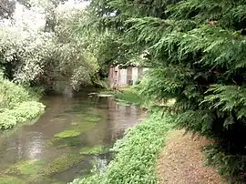 The Liger river | |
 Coat of arms | |
Location of Saint-Aubin-Rivière | |
 Saint-Aubin-Rivière  Saint-Aubin-Rivière | |
| Coordinates: 49°52′14″N 1°46′31″E | |
| Country | France |
| Region | Hauts-de-France |
| Department | Somme |
| Arrondissement | Amiens |
| Canton | Poix-de-Picardie |
| Intercommunality | CC Somme Sud-Ouest |
| Government | |
| • Mayor (2020–2026) | Denis Lejeune[1] |
| Area 1 | 3.08 km2 (1.19 sq mi) |
| Population | 113 |
| • Density | 37/km2 (95/sq mi) |
| Time zone | UTC+01:00 (CET) |
| • Summer (DST) | UTC+02:00 (CEST) |
| INSEE/Postal code | 80699 /80430 |
| Elevation | 87–188 m (285–617 ft) (avg. 126 m or 413 ft) |
| 1 French Land Register data, which excludes lakes, ponds, glaciers > 1 km2 (0.386 sq mi or 247 acres) and river estuaries. | |
Geography
The commune is situated some 14 miles (23 km) south of Abbeville, on the D211 road and on the banks of the river Liger.
Population
| Year | Pop. | ±% p.a. |
|---|---|---|
| 1968 | 173 | — |
| 1975 | 113 | −5.90% |
| 1982 | 125 | +1.45% |
| 1990 | 123 | −0.20% |
| 1999 | 113 | −0.94% |
| 2007 | 113 | +0.00% |
| 2012 | 112 | −0.18% |
| 2017 | 111 | −0.18% |
| Source: INSEE[3] | ||
Places of interest
- The church
- The watermill
See also
References
- "Répertoire national des élus: les maires". data.gouv.fr, Plateforme ouverte des données publiques françaises (in French). 2 December 2020.
- "Populations légales 2020". The National Institute of Statistics and Economic Studies. 29 December 2022.
- Population en historique depuis 1968, INSEE
Wikimedia Commons has media related to Saint-Aubin-Rivière.
This article is issued from Wikipedia. The text is licensed under Creative Commons - Attribution - Sharealike. Additional terms may apply for the media files.