Fourdrinoy
Fourdrinoy (French pronunciation: [fuʁdʁinwa]) is a commune in the Somme department in Hauts-de-France in northern France.
Fourdrinoy | |
|---|---|
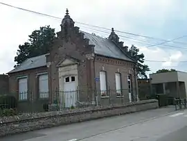 The town hall in Fourdrinoy | |
Location of Fourdrinoy | |
 Fourdrinoy  Fourdrinoy | |
| Coordinates: 49°55′06″N 2°06′26″E | |
| Country | France |
| Region | Hauts-de-France |
| Department | Somme |
| Arrondissement | Amiens |
| Canton | Ailly-sur-Somme |
| Intercommunality | CC Nièvre et Somme |
| Government | |
| • Mayor (2020–2026) | Manuel Guillot[1] |
| Area 1 | 9.12 km2 (3.52 sq mi) |
| Population | 393 |
| • Density | 43/km2 (110/sq mi) |
| Time zone | UTC+01:00 (CET) |
| • Summer (DST) | UTC+02:00 (CEST) |
| INSEE/Postal code | 80341 /80310 |
| Elevation | 42–120 m (138–394 ft) (avg. 106 m or 348 ft) |
| 1 French Land Register data, which excludes lakes, ponds, glaciers > 1 km2 (0.386 sq mi or 247 acres) and river estuaries. | |
Geography
Fourdrinoy is situated 6 miles (10 km) northwest of Amiens on the D121 road
Population
| Year | Pop. | ±% p.a. |
|---|---|---|
| 1968 | 268 | — |
| 1975 | 276 | +0.42% |
| 1982 | 340 | +3.02% |
| 1990 | 334 | −0.22% |
| 1999 | 326 | −0.27% |
| 2007 | 347 | +0.78% |
| 2012 | 368 | +1.18% |
| 2017 | 417 | +2.53% |
| Source: INSEE[3] | ||
See also
References
- "Répertoire national des élus: les maires". data.gouv.fr, Plateforme ouverte des données publiques françaises (in French). 2 December 2020.
- "Populations légales 2020". The National Institute of Statistics and Economic Studies. 29 December 2022.
- Population en historique depuis 1968, INSEE
External links
Wikimedia Commons has media related to Fourdrinoy.
- Fourdrinoy resident’s website (in French)
This article is issued from Wikipedia. The text is licensed under Creative Commons - Attribution - Sharealike. Additional terms may apply for the media files.