Cerisy-Buleux
Cerisy-Buleux (French pronunciation: [səʁizi bylø]) is a commune in the Somme department in Hauts-de-France in northern France.
Cerisy-Buleux | |
|---|---|
%252C_France_(2).JPG.webp) The church in Cerisy-Buleux | |
.svg.png.webp) Coat of arms | |
Location of Cerisy-Buleux | |
 Cerisy-Buleux  Cerisy-Buleux | |
| Coordinates: 49°58′33″N 1°44′23″E | |
| Country | France |
| Region | Hauts-de-France |
| Department | Somme |
| Arrondissement | Amiens |
| Canton | Poix-de-Picardie |
| Intercommunality | CC Somme Sud-Ouest |
| Government | |
| • Mayor (2020–2026) | Dominique Bayart[1] |
| Area 1 | 5.6 km2 (2.2 sq mi) |
| Population | 267 |
| • Density | 48/km2 (120/sq mi) |
| Time zone | UTC+01:00 (CET) |
| • Summer (DST) | UTC+02:00 (CEST) |
| INSEE/Postal code | 80183 /80140 |
| Elevation | 96–127 m (315–417 ft) (avg. 103 m or 338 ft) |
| 1 French Land Register data, which excludes lakes, ponds, glaciers > 1 km2 (0.386 sq mi or 247 acres) and river estuaries. | |
Geography
The commune is situated on the D190 road, some 15 miles (24 km) southwest of Abbeville.
Population
| Year | Pop. | ±% p.a. |
|---|---|---|
| 1968 | 342 | — |
| 1975 | 281 | −2.77% |
| 1982 | 272 | −0.46% |
| 1990 | 278 | +0.27% |
| 1999 | 260 | −0.74% |
| 2007 | 254 | −0.29% |
| 2012 | 260 | +0.47% |
| 2017 | 266 | +0.46% |
| 2019 | 264 | −0.38% |
| Source: INSEE[3] | ||
Places of interest
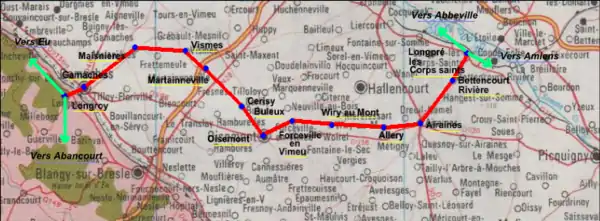
- The old railway line:[4]
The railway, opened in 1872, was closed on 10 November 1993. Mostly freight trains for the many farming cooperatives, there were also a few passenger trains.
%252C_France_(5).JPG.webp) Townhall.
Townhall.%252C_France_(7).JPG.webp) Old school.
Old school.%252C_France_(6).JPG.webp) Monument.
Monument.%252C_France.JPG.webp) Castle, Arleux street.
Castle, Arleux street.%252C_France_(3).JPG.webp) Castle, near the church.
Castle, near the church.
Personality
- Jean Tagault (circa 1499–1546), anatomist and surgeon.
References
- "Répertoire national des élus: les maires". data.gouv.fr, Plateforme ouverte des données publiques françaises (in French). 2 December 2020.
- "Populations légales 2020". The National Institute of Statistics and Economic Studies. 29 December 2022.
- Population en historique depuis 1968, INSEE
- Source:Fcvnet
This article is issued from Wikipedia. The text is licensed under Creative Commons - Attribution - Sharealike. Additional terms may apply for the media files.