Fourcigny
Fourcigny (French pronunciation: [fuʁsiɲi]) is a commune in the Somme department in Hauts-de-France in northern France.
Fourcigny | |
|---|---|
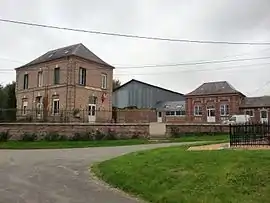 The town hall and school in Fourcigny | |
.svg.png.webp) Coat of arms | |
Location of Fourcigny | |
 Fourcigny  Fourcigny | |
| Coordinates: 49°45′37″N 1°49′36″E | |
| Country | France |
| Region | Hauts-de-France |
| Department | Somme |
| Arrondissement | Amiens |
| Canton | Poix-de-Picardie |
| Intercommunality | CC Somme Sud-Ouest |
| Government | |
| • Mayor (2022–2026) | Jack Warnault[1] |
| Area 1 | 4.55 km2 (1.76 sq mi) |
| Population | 200 |
| • Density | 44/km2 (110/sq mi) |
| Time zone | UTC+01:00 (CET) |
| • Summer (DST) | UTC+02:00 (CEST) |
| INSEE/Postal code | 80340 /80290 |
| Elevation | 193–214 m (633–702 ft) (avg. 142 m or 466 ft) |
| 1 French Land Register data, which excludes lakes, ponds, glaciers > 1 km2 (0.386 sq mi or 247 acres) and river estuaries. | |
Geography
Fourcigny is situated in the southeastern corner of the département, 26 miles (42 km) southwest of Amiens on the D98, a few hundred yards from the Oise department and a few miles from the border with the Seine-Maritime. The hamlet of Beaurepaire adjoins.
Population
| Year | Pop. | ±% p.a. |
|---|---|---|
| 1968 | 164 | — |
| 1975 | 130 | −3.26% |
| 1982 | 131 | +0.11% |
| 1990 | 123 | −0.78% |
| 1999 | 131 | +0.70% |
| 2007 | 171 | +3.39% |
| 2012 | 188 | +1.91% |
| 2017 | 193 | +0.53% |
| Source: INSEE[3] | ||
See also
References
- "Répertoire national des élus: les maires" (in French). data.gouv.fr, Plateforme ouverte des données publiques françaises. 4 May 2022.
- "Populations légales 2020". The National Institute of Statistics and Economic Studies. 29 December 2022.
- Population en historique depuis 1968, INSEE
Wikimedia Commons has media related to Fourcigny.
This article is issued from Wikipedia. The text is licensed under Creative Commons - Attribution - Sharealike. Additional terms may apply for the media files.