Saint-Jean-de-Soudain
Saint-Jean-de-Soudain (French pronunciation: [sɛ̃ ʒɑ̃ də sudɛ̃]) is a commune in the Isère department in southeastern France.[3]
Saint-Jean-de-Soudain | |
|---|---|
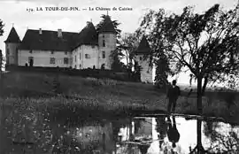 The château of Cuirieu in the early 20th century | |
 Coat of arms | |
Location of Saint-Jean-de-Soudain | |
 Saint-Jean-de-Soudain  Saint-Jean-de-Soudain | |
| Coordinates: 45°34′24″N 5°25′47″E | |
| Country | France |
| Region | Auvergne-Rhône-Alpes |
| Department | Isère |
| Arrondissement | La Tour-du-Pin |
| Canton | La Tour-du-Pin |
| Intercommunality | Les Vals du Dauphiné |
| Government | |
| • Mayor (2020–2026) | Alain Courbou[1] |
| Area 1 | 7.48 km2 (2.89 sq mi) |
| Population | 1,661 |
| • Density | 220/km2 (580/sq mi) |
| Time zone | UTC+01:00 (CET) |
| • Summer (DST) | UTC+02:00 (CEST) |
| INSEE/Postal code | 38401 /38110 |
| Elevation | 303–471 m (994–1,545 ft) (avg. 389 m or 1,276 ft) |
| 1 French Land Register data, which excludes lakes, ponds, glaciers > 1 km2 (0.386 sq mi or 247 acres) and river estuaries. | |
Geography
The Bourbre flows west through the middle of the commune and crosses the village.
Population
|
|
See also
References
- "Répertoire national des élus: les maires". data.gouv.fr, Plateforme ouverte des données publiques françaises (in French). 9 August 2021.
- "Populations légales 2020". The National Institute of Statistics and Economic Studies. 29 December 2022.
- INSEE commune file
Wikimedia Commons has media related to Saint-Jean-de-Soudain.
This article is issued from Wikipedia. The text is licensed under Creative Commons - Attribution - Sharealike. Additional terms may apply for the media files.