Morestel
Morestel (French pronunciation: [mɔʁɛstɛl]; Arpitan: Mouretél) is a commune in the Isère department in south-eastern France.[3]
Morestel | |
|---|---|
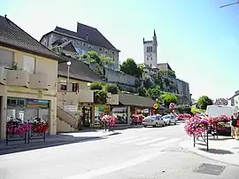 The centre of Morestel | |
 Coat of arms | |
Location of Morestel | |
 Morestel  Morestel | |
| Coordinates: 45°40′43″N 5°28′15″E | |
| Country | France |
| Region | Auvergne-Rhône-Alpes |
| Department | Isère |
| Arrondissement | La Tour-du-Pin |
| Canton | Morestel |
| Intercommunality | Les Balcons du Dauphiné |
| Government | |
| • Mayor (2020–2026) | Frédéric Vial[1] |
| Area 1 | 8.03 km2 (3.10 sq mi) |
| Population | 4,492 |
| • Density | 560/km2 (1,400/sq mi) |
| Time zone | UTC+01:00 (CET) |
| • Summer (DST) | UTC+02:00 (CEST) |
| INSEE/Postal code | 38261 /38510 |
| Elevation | 205–319 m (673–1,047 ft) |
| 1 French Land Register data, which excludes lakes, ponds, glaciers > 1 km2 (0.386 sq mi or 247 acres) and river estuaries. | |
Geography
Morestel is situated on the old National Highway 75, now RD 1075, between Bourg-en-Bresse and Grenoble.
Population
|
|
See also
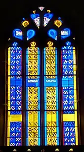
The stained glass of the parish church of saint Symphorianus.
References
- "Répertoire national des élus: les maires" (in French). data.gouv.fr, Plateforme ouverte des données publiques françaises. 4 May 2022.
- "Populations légales 2020". The National Institute of Statistics and Economic Studies. 29 December 2022.
- INSEE commune file
External links
Wikimedia Commons has media related to Morestel.
This article is issued from Wikipedia. The text is licensed under Creative Commons - Attribution - Sharealike. Additional terms may apply for the media files.