La Pierre
La Pierre (French pronunciation: [la pjɛʁ]) is a commune in the Isère department in southeastern France.[3] It is part of the Grenoble urban unit (agglomeration).[4]
La Pierre | |
|---|---|
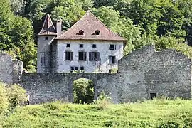 Manor of Veaubeaunnais | |
Location of La Pierre | |
 La Pierre  La Pierre | |
| Coordinates: 45°17′40″N 5°56′57″E | |
| Country | France |
| Region | Auvergne-Rhône-Alpes |
| Department | Isère |
| Arrondissement | Grenoble |
| Canton | Le Haut-Grésivaudan |
| Intercommunality | CC Le Grésivaudan |
| Government | |
| • Mayor (2020–2026) | Jean-Yves Gayet[1] |
| Area 1 | 3 km2 (1 sq mi) |
| Population | 584 |
| • Density | 190/km2 (500/sq mi) |
| Time zone | UTC+01:00 (CET) |
| • Summer (DST) | UTC+02:00 (CEST) |
| INSEE/Postal code | 38303 /38570 |
| Elevation | 225–452 m (738–1,483 ft) (avg. 233 m or 764 ft) |
| 1 French Land Register data, which excludes lakes, ponds, glaciers > 1 km2 (0.386 sq mi or 247 acres) and river estuaries. | |
The commune is surrounded by agricultural land, giving the village its rural character.
Population
|
|
See also
References
- "Répertoire national des élus: les maires". data.gouv.fr, Plateforme ouverte des données publiques françaises (in French). 2 December 2020.
- "Populations légales 2020". The National Institute of Statistics and Economic Studies. 29 December 2022.
- INSEE commune file
- Unité urbaine 2020 de Grenoble (38701), INSEE
External links
Wikimedia Commons has media related to La Pierre.
This article is issued from Wikipedia. The text is licensed under Creative Commons - Attribution - Sharealike. Additional terms may apply for the media files.