Pact, Isère
Pact (French pronunciation: [pakt]) is a commune in the Isère department in southeastern France.[3]
Pact | |
|---|---|
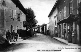 The main road in 1908 | |
Location of Pact | |
 Pact  Pact | |
| Coordinates: 45°21′13″N 4°59′32″E | |
| Country | France |
| Region | Auvergne-Rhône-Alpes |
| Department | Isère |
| Arrondissement | Vienne |
| Canton | Roussillon |
| Intercommunality | Entre Bièvre et Rhône |
| Government | |
| • Mayor (2020–2026) | Laurent Iltis[1] |
| Area 1 | 9.74 km2 (3.76 sq mi) |
| Population | 858 |
| • Density | 88/km2 (230/sq mi) |
| Time zone | UTC+01:00 (CET) |
| • Summer (DST) | UTC+02:00 (CEST) |
| INSEE/Postal code | 38290 /38270 |
| Elevation | 238–309 m (781–1,014 ft) |
| 1 French Land Register data, which excludes lakes, ponds, glaciers > 1 km2 (0.386 sq mi or 247 acres) and river estuaries. | |
Population
| Year | Pop. | ±% p.a. |
|---|---|---|
| 1968 | 462 | — |
| 1975 | 471 | +0.28% |
| 1982 | 480 | +0.27% |
| 1990 | 560 | +1.95% |
| 1999 | 642 | +1.53% |
| 2007 | 776 | +2.40% |
| 2012 | 845 | +1.72% |
| 2017 | 841 | −0.09% |
| Source: INSEE[4] | ||
See also
References
Wikimedia Commons has media related to Pact.
- "Répertoire national des élus: les maires". data.gouv.fr, Plateforme ouverte des données publiques françaises (in French). 9 August 2021.
- "Populations légales 2020". The National Institute of Statistics and Economic Studies. 29 December 2022.
- INSEE commune file
- Population en historique depuis 1968, INSEE
This article is issued from Wikipedia. The text is licensed under Creative Commons - Attribution - Sharealike. Additional terms may apply for the media files.