Rahmatabad and Blukat District
Rahmatabad and Blukat District (Persian: بخش رحمتآباد و بلوکات) is in Rudbar County, Gilan province, Iran. Its capital is the city of Tutkabon.
Rahmatabad and Blukat District
Persian: بخش رحمتآباد و بلوکات | |
|---|---|
 Rahmatabad and Blukat District | |
| Coordinates: 36°57′17″N 49°36′16″E[1] | |
| Country | |
| Province | Gilan |
| County | Rudbar |
| Capital | Tutkabon |
| Population (2016)[2] | |
| • Total | 14,891 |
| Time zone | UTC+3:30 (IRST) |
At the 2006 National Census, its population was 17,652 in 4,759 households.[3] The following census in 2011 counted 15,567 people in 4,721 households.[4] At the latest census in 2016, the district had 14,891 inhabitants in 5,041 households.[2]
| Administrative Divisions | 2006[3] | 2011[4] | 2016[2] |
|---|---|---|---|
| Blukat RD | 5,710 | 4,859 | 4,440 |
| Dasht-e Veyl RD | 5,416 | 4,628 | 4,927 |
| Rahmatabad RD | 4,855 | 4,402 | 4,014 |
| Tutkabon (city) | 1,671 | 1,678 | 1,510 |
| Total | 17,652 | 15,567 | 14,891 |
| RD: Rural District | |||
References
- OpenStreetMap contributors (8 October 2023). "Rahmatabad and Blukat District (Rudbar County)" (Map). OpenStreetMap. Retrieved 8 October 2023.
- "Census of the Islamic Republic of Iran, 1395 (2016)". AMAR (in Persian). The Statistical Center of Iran. p. 01. Archived from the original (Excel) on 4 December 2020. Retrieved 19 December 2022.
- "Census of the Islamic Republic of Iran, 1385 (2006)". AMAR (in Persian). The Statistical Center of Iran. p. 01. Archived from the original (Excel) on 20 September 2011. Retrieved 25 September 2022.
- "Census of the Islamic Republic of Iran, 1390 (2011)" (Excel). Iran Data Portal (in Persian). The Statistical Center of Iran. p. 01. Retrieved 19 December 2022.
| Capital | 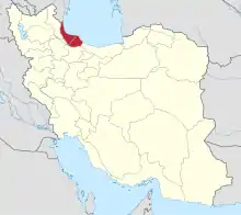 | |
|---|---|---|
| Counties and cities | ||
| Sights |
| |
| Populated places | ||
| Capital | |||||||||||||||||||||||||||||||||||||||||||||
|---|---|---|---|---|---|---|---|---|---|---|---|---|---|---|---|---|---|---|---|---|---|---|---|---|---|---|---|---|---|---|---|---|---|---|---|---|---|---|---|---|---|---|---|---|---|
| Districts |
| ||||||||||||||||||||||||||||||||||||||||||||
This article is issued from Wikipedia. The text is licensed under Creative Commons - Attribution - Sharealike. Additional terms may apply for the media files.