Pommereuil
Pommereuil (French pronunciation: [pɔmʁœj]; also: Le Pommereuil) is a commune in the Nord department in northern France.[3]
Pommereuil | |
|---|---|
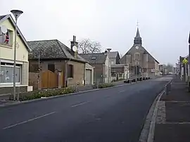 A view within Pommereuil | |
_Nord-France.svg.png.webp) Coat of arms | |
Location of Pommereuil | |
 Pommereuil  Pommereuil | |
| Coordinates: 50°06′46″N 3°35′48″E | |
| Country | France |
| Region | Hauts-de-France |
| Department | Nord |
| Arrondissement | Cambrai |
| Canton | Le Cateau-Cambrésis |
| Intercommunality | CA Caudrésis–Catésis |
| Government | |
| • Mayor (2020–2026) | Pascal Paquet[1] |
| Area 1 | 6.45 km2 (2.49 sq mi) |
| Population | 778 |
| • Density | 120/km2 (310/sq mi) |
| Time zone | UTC+01:00 (CET) |
| • Summer (DST) | UTC+02:00 (CEST) |
| INSEE/Postal code | 59465 /59360 |
| Elevation | 91–153 m (299–502 ft) |
| 1 French Land Register data, which excludes lakes, ponds, glaciers > 1 km2 (0.386 sq mi or 247 acres) and river estuaries. | |
History
The village and surrounding woods (Bois l'Évêque) were heavily damaged by a tornado on 24 June 1967, a relatively rare occurrence in France.
Heraldry
Arms of Pommereuil |
The arms of Pommereuil are blazoned : Argent, a cross moline sable. (Challes-les-Eaux, Montalembert, Neuvilly and Pommereuil use the same arms.)
|
Monuments
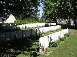
Pommereuil British Cemetery
- The church, Église Saint-Michel, was built during the 17th Century and has a fortified tower.
See also
References
- "Répertoire national des élus: les maires". data.gouv.fr, Plateforme ouverte des données publiques françaises (in French). 9 August 2021.
- "Populations légales 2020". The National Institute of Statistics and Economic Studies. 29 December 2022.
- INSEE commune file
Wikimedia Commons has media related to Pommereuil.
This article is issued from Wikipedia. The text is licensed under Creative Commons - Attribution - Sharealike. Additional terms may apply for the media files.