Flêtre
Flêtre (French pronunciation: [flɛtʁ]; from Dutch: Vleteren) is a commune in the Nord department in northern France.[3]
Flêtre
Vleteren | |
|---|---|
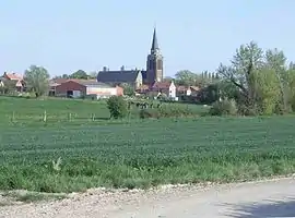 A general view of Flêtre | |
_Nord-France.svg.png.webp) Coat of arms | |
Location of Flêtre | |
 Flêtre  Flêtre | |
| Coordinates: 50°45′14″N 2°38′51″E | |
| Country | France |
| Region | Hauts-de-France |
| Department | Nord |
| Arrondissement | Dunkerque |
| Canton | Bailleul |
| Intercommunality | CC Flandre Intérieure |
| Government | |
| • Mayor (2020–2026) | Philippe Masquelier[1] |
| Area 1 | 8.98 km2 (3.47 sq mi) |
| Population | 992 |
| • Density | 110/km2 (290/sq mi) |
| Demonym | Flêtrois(es) |
| Time zone | UTC+01:00 (CET) |
| • Summer (DST) | UTC+02:00 (CEST) |
| INSEE/Postal code | 59237 /59270 |
| Elevation | 26–88 m (85–289 ft) (avg. 47 m or 154 ft) |
| 1 French Land Register data, which excludes lakes, ponds, glaciers > 1 km2 (0.386 sq mi or 247 acres) and river estuaries. | |
Bertenacre Military Cemetery, a British military cemetery with casualties from both world wars, is located three kilometers north of Flêtre.
Heraldry
Arms of Flêtre |
The arms of Flêtre are blazoned : Argent, 3 demi-fleurs de lys gules.
|
See also
References
- "Répertoire national des élus: les maires". data.gouv.fr, Plateforme ouverte des données publiques françaises (in French). 9 August 2021.
- "Populations légales 2020". The National Institute of Statistics and Economic Studies. 29 December 2022.
- INSEE commune file
Wikimedia Commons has media related to Flêtre.
This article is issued from Wikipedia. The text is licensed under Creative Commons - Attribution - Sharealike. Additional terms may apply for the media files.