Wills Developmental Road
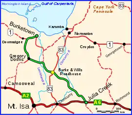
The Wills Developmental Road is a road in north-west Queensland running between Julia Creek and Burketown.[1] As of 2016 it is sealed with a total length of 500 kilometres (310 mi). There are no major towns along the entire route, but fuel and supplies are available at the Burke and Wills Roadhouse at Four Ways, and also at Gregory. The Wills Developmental Road joins the Burke Developmental Road for approximately 1.2 kilometres, avoiding a direct crossroads at their intersection. Two major rivers are crossed by the Wills Developmental Road en route, the Cloncurry and the Leichhardt.[2]
Wills Developmental Road | |
|---|---|
 | |
| Wills Developmental Road (green and black) | |
| General information | |
| Type | Rural road |
| Length | 500 km (311 mi) |
| Route number(s) | |
| Major junctions | |
| South-east end | |
| North-west end | Burketown |
| Location(s) | |
| Major settlements | Gregory |

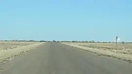
Wills Developmental Road, Taldora, Gulf Country, June 2019

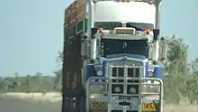
Road train on the Wills Developmental Road, Four Ways, June 2019
Major intersections
| LGA | Location | km | mi | Destinations | Notes |
|---|---|---|---|---|---|
| McKinlay | Julia Creek | 0 | 0.0 | Southern end of Wills Developmental Road (State Route 84) | |
| Cloncurry | Four Ways | 233 | 145 | south - Cloncurry | Southern concurrency terminus with Burke Developmental Road |
| 234 | 145 | Northern concurrency terminus with Burke Developmental Road | |||
| Burke | Gregory | 380 | 240 | ||
| Nicholson | 475 | 295 | north-east - Burketown | Southern concurrency terminus with National Route 1 | |
| Burketown | 500 | 310 | Northern concurrency terminus with National Route 1. Northern end of Wills Developmental Road. | ||
1.000 mi = 1.609 km; 1.000 km = 0.621 mi
| |||||
References
Wikimedia Commons has media related to Wills Developmental Road.
- "Queensland Government - Department of Transport and Main Roads - Maps". Archived from the original on 19 March 2018. Retrieved 16 March 2016.
- Hema, Maps (2007). Australia Road and 4WD Atlas (Map). Eight Mile Plains Queensland: Hema Maps. p. 12. ISBN 978-1-86500-456-3.
This article is issued from Wikipedia. The text is licensed under Creative Commons - Attribution - Sharealike. Additional terms may apply for the media files.