Burnett Highway
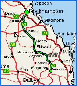
The Burnett Highway is an inland rural highway located in Queensland, Australia. The highway runs from its junction with the Bruce Highway at Gracemere, just south of Rockhampton, to Nanango. Its length is approximately 542 kilometres. The highway takes its name from the Burnett River, which it crosses in Gayndah. The Burnett Highway provides the most direct link between the northern end of the New England Highway (at Yarraman, 21 kilometres (13 mi) south of Nanango) and Rockhampton. It is designated as a State Strategic Road (part of Australia’s Country Way) by the Queensland Government.[1]
Burnett Highway | |
|---|---|
 | |
| Burnett Highway (green on black) | |
| General information | |
| Type | Highway |
| Length | 542 km (337 mi) |
| Route number(s) |
|
| Former route number | |
| Major junctions | |
| North end | |
| |
| South end | |
| Location(s) | |
| Major settlements | Mt. Morgan, Dululu, Biloela, Monto, Eidsvold, Mundubbera, Gayndah, Ban Ban Springs, Goomeri |
| Highway system | |
History
In January 2013, Cyclone Oswald caused flood damage to the road and a partial closure between Bouldercombe and Mount Morgan, which took longer than a year to repair.[2]
Roads of Strategic Importance upgrade
The Roads of Strategic Importance initiative, last updated in March 2022, includes the following project for the Burnett Highway.
Intersection upgrade
A project to upgrade the intersection of the Burnett Highway with Gayndah-Mount Perry Road and Wetherton Road, at an estimated cost of $875,000, is expected to be completed in late 2022.[3]
Other upgrades
Replace bridges
A project to replace the bridge over Three Moon Creek, at a cost of $18 million, was completed in August 2021.[4]
A project to replace the bridge over North Kariboe Creek, at a cost of $7.2 million, was completed in September 2021.[5]
Strengthen and widen bridge
A project to strengthen and widen the bridge over Callide Creek, at a cost of $3.9 million, was due for completion in early 2022.[6]
List of towns on the Burnett Highway
From north to south
Gallery
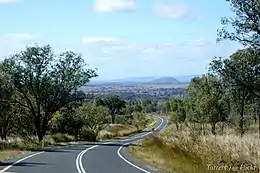 Burnett Highway near Binjour (NW of Gayndah)
Major intersections
| LGA | Location | km | mi | Destinations | Notes |
|---|---|---|---|---|---|
| Rockhampton | Gracemere | 0 | 0.0 | south – Mount Larcom | Northern end of Burnett Highway. |
| Banana | Dululu | 63.0 | 39.1 | south–west – Wowan | |
| Biloela | 135.1 | 83.9 | east – Calliope | North–western concurrency terminus with Dawson Highway | |
| 136.3 | 84.7 | east – Calliope | South–eastern concurrency terminus with Dawson Highway | ||
| North Burnett | Monto | 230 | 140 | ||
| Eidsvold | 303 | 188 | |||
| Mundubbera | 338.3 | 210.2 | |||
| Burnett River | 381.3 | 236.9 | Les Baker Bridge | ||
| North Burnett | Ban Ban Springs | 408.1 | 253.6 | ||
| Gympie | Goomeri | 482.3 | 299.7 | Northern concurrency terminus with State Route 49 | |
| 484.1 | 300.8 | Southern concurrency terminus with State Route 49 | |||
| South Burnett | Nanango | 542.3 | 337.0 | (State Route 96) north–west – Kingaroy | Southern end of Burnett Highway. |
1.000 mi = 1.609 km; 1.000 km = 0.621 mi
| |||||
References
- "Queensland Government - Department of Transport and Main Roads - Maps". Archived from the original on 19 March 2018. Retrieved 20 April 2014.
- Austin King (12 April 2014). "Burnett Hwy still closed more than a year after landslide". The Morning Bulletin. Capricornia Newspapers. Retrieved 29 July 2014.
- "Burnett Highway - Gayndah-Mount Perry Road - Wetherton Road - Intersection Upgrade". Department of Infrastructure, Transport, Regional Development and Communications. 29 March 2022. Retrieved 6 May 2022.
- "Burnett Highway (Gayndah-Monto), Eidsvold, -Three Moon Creek bridge replacement". Queensland Government. 2 February 2022. Retrieved 31 May 2022.
- "Burnett Highway (Monto-Biloela), North Kariboe Creek, replace bridge". Queensland Government. 23 November 2021. Retrieved 31 May 2022.
- "Burnett Highway (Biloela-Mount Morgan), Callide Creek, strengthen and widen bridge". Queensland Government. 22 November 2021. Retrieved 31 May 2022.