Gulf Developmental Road
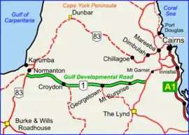
Gulf Developmental Road is an Australian highway linking the Cairns and Normanton regions in northern Queensland, Australia. It is the only sealed (asphalt) road linking these two regions.[1]
Gulf Developmental Road | |
|---|---|
 | |
| Gulf Developmental Road (green on black) | |
| General information | |
| Type | Rural road |
| Length | 442 km (275 mi) |
| Route number(s) | |
| Major junctions | |
| West end | |
| Gregory Highway | |
| East end | |
| Location(s) | |
| Major settlements | Croydon, Georgetown, Mount Surprise |
In the east, the road begins at an unnamed junction on the southern edge of Forty Mile Scrub National Park, 241 km (150 mi) south-west of Cairns. The Gulf Developmental Road runs west before terminating at its junction with the Burke Developmental Road 7 km (4.3 mi) south of Normanton, a total distance of 442 km (275 mi). Towns along the route include Mount Surprise, Georgetown and Croydon.[2] There are no other communities along the route, but it passes through the ghost town of Cumberland. The road is sealed for its full length, but as of 2018 there are many sections of the road which are only single lane bitumen. These sections require caution when passing other traffic as the shoulders are gravel and vehicles need to move partly onto the shoulders. They extend between points about 55 kilometres west of Georgetown and 20 kilometres west of Mount Surprise.
The Gulf Developmental Road is designated Highway 1; it is not part of the National Highway network.
Major intersections
This road has only one major intersection, with the Gregory Highway in the locality of Mount Surprise.
Upgrades
The Roads of Strategic Importance initiative, last updated in March 2022, includes the following projects for the Gulf Developmental Road.
Corridor upgrade
A lead project to upgrade the Cairns to Northern Territory border corridor, including the Gulf Developmental Road and surrounding state and council roads, at an estimated cost of $62.5 million, was commenced in 2020, with planning continuing.[3]
Pavement strengthening and widening
A project for pavement strengthening and widening of sections of the Gulf Developmental Road between Mount Garnett and Croyden at a cost of $21.5 million is planned to be completed by mid-2022.[4] This project is targeted for "early works" by the Queensland Government, and is split into two packages.[5]
References
- Hema, Maps (2007). Australia Road and 4WD Atlas (Map). Eight Mile Plains Queensland: Hema Maps. pp. 11–12. ISBN 978-1-86500-456-3.
- Queensland Government - Department of Transport and Main Roads - Maps
- "Cairns to Northern Territory Border Corridor Upgrade - Future Priorities". Department of Infrastructure, Transport, Regional Development and Communications. 29 March 2022. Retrieved 6 May 2022.
- "Gulf Developmental Road - Pavement Strengthening and Widening". Department of Infrastructure, Transport, Regional Development and Communications. 8 November 2021. Retrieved 6 May 2022.
- "ROSI early works package" (PDF). Queensland Government. 29 April 2020. Retrieved 7 May 2022.