Bulloo Developmental Road
The Bulloo Developmental Road is an outback road in Queensland, Australia. It is part of the Adventure Way, a route from Brisbane to Adelaide via the Australian outback.[1]
Bulloo Developmental Road | |
|---|---|
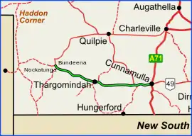 | |
| Bulloo Developmental Road (green on black) | |
| General information | |
| Type | Rural road |
| Length | 361 km (224 mi) |
| Major junctions | |
| East end | |
| West end | |
| Location(s) | |
| Major settlements | Eulo, Lake Bindegolly National Park, Thargomindah |
It commences at Cunnamulla and travels approximately west for 361 kilometres (224 mi) until it meets the Cooper Developmental Road at 27.3587°S 142.5718°E.
Updates
Widen and seal
A project to widen and seal sections of the road, at a cost of $4.5 million, was due to commence in October 2021.[2]
Locations on the route
From east to west:[3]
- Cunnamulla (0 kilometres (0 mi)
- Eulo (67 kilometres (42 mi))
- Lake Bindegolly National Park in Dynevor (153 kilometres (95 mi))
- Thargomindah (197 kilometres (122 mi))
Major intersections
| LGA | Location | km | mi | Destinations | Notes |
|---|---|---|---|---|---|
| Paroo | Cunnamulla | 0 | 0.0 | east (via south - Bourke | Eastern end of Bulloo Developmental Road. The road proceeds west through Cunnamulla via Emma, Wicks, and Louise Streets. |
| Warrego River | 2.3 | 1.4 | Darby Land Bridge | ||
| Paroo River | 70.5 | 43.8 | Bridge | ||
| Paroo | Eulo | 73.5 | 45.7 | Hungerford Road - south - Hungerford | |
| Lake Bindegolly | 155 | 96 | Bridge | ||
| Bulloo | Dynevor - Norley[4] boundary | 191 | 119 | Quilpie Thargomindah Road - north - Quilpie | Eastern concurrency terminus with the Dowling Track,[5] a series of roads that follows the historic stock route from Bourke to Quilpie via Hungerford and Thargomindah |
| Dynevor - Thargomindah boundary | 196 | 122 | Thargomindah Hungerford Road - south - Hungerford | Western concurrency terminus with the Dowling Track | |
| Wilson River | 316 | 196 | Bridge | ||
| Bulloo | Nockatunga | 320 | 200 | Warry Gate Road - south - Noccundra, Tibooburra, and Broken Hill | |
| 327 | 203 | Adventure Way (Innamincka Road) - west - Innamincka | |||
| Durham | 361 | 224 | Cooper Developmental Road - east - Quilpie / Woomanooka Road - west - Tanbar | Western end of Bulloo Developmental Road | |
1.000 mi = 1.609 km; 1.000 km = 0.621 mi
| |||||
References
- "Adventure Way". Outback Queensland. Retrieved 12 November 2019.
- "Bulloo Developmental Road (Cunnamulla-Thargomindah), widen and seal". Queensland Government. 24 November 2021. Retrieved 22 May 2022.
- "Adventure Way: Brisbane to Innamincka". Queensland Uncovered. Retrieved 12 November 2019.
- Google (1 August 2017). "Norley, Queensland" (Map). Google Maps. Google. Retrieved 1 August 2017.
- "The Dowling Track". Outback Beds. 7 December 2018. Retrieved 12 November 2019.
This article is issued from Wikipedia. The text is licensed under Creative Commons - Attribution - Sharealike. Additional terms may apply for the media files.