Bunya Highway
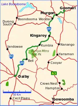
The Bunya Highway is a state highway of Queensland, Australia. It is a relatively short road, running approximately 173 kilometres in a south-westerly direction from Goomeri to Dalby. The highway connects the Warrego and Burnett Highways.[1]
Bunya Highway | |
|---|---|
 | |
| Bunya Highway (green and black) | |
| General information | |
| Type | Highway |
| Length | 173 km (107 mi) |
| Route number(s) | |
| Major junctions | |
| North end | |
| South end | |
| Location(s) | |
| Major settlements | Murgon, Wondai, Kingaroy, Kumbia, Bell |
| Highway system | |
The Bunya Highway passes near the Bunya Mountains National Park, which is popular with tourists. The highway is named after the Bunya-bunya Araucaria bidwilli, which grows in the area and the seeds of which were (and still are) a favourite food of the Aborigines.
The road continues east of Goomeri as the Wide Bay Highway, connecting it to Gympie.[2]
In 2008, the intersection with Burnett Highway was reconstructed to favour Murgon-bound traffic.
List of towns along the Bunya Highway

Old closed shops on Bunya Highway, main street in Memerambi, 2023.jpg
Major intersections
| LGA | Location | km | mi | Destinations | Notes |
|---|---|---|---|---|---|
| Gympie | Goomeri | 0 | 0.0 | Northern end of Bunya Highway. Northern concurrency terminus with Burnett Highway | |
| 1.8 | 1.1 | Southern concurrency terminus with Burnett Highway | |||
| South Burnett | Kingaroy | 62.0 | 38.5 | ||
| Kumbia | 94.6 | 58.8 | Bunya Mountains Road - south - Bunya Mountains | ||
| Western Downs | Dalby | 170.3 | 105.8 | Dalby-Cooyar Road - east - Cooyar | |
| 172.2 | 107.0 | west - Chinchilla | Southern end of Bunya Highway. State Route 49 continues north-west for 450 metres, duplexed with the Warrego Highway, before turning south-west as the Moonie Highway. | ||
1.000 mi = 1.609 km; 1.000 km = 0.621 mi
| |||||
References
Wikimedia Commons has media related to Bunya Highway.
- Queensland Government - Department of Transport and Main Roads - Maps
- Hema, Maps (2007). Australia Road and 4WD Atlas (Map). Eight Mile Plains Queensland: Hema Maps. p. 9. ISBN 978-1-86500-456-3.
This article is issued from Wikipedia. The text is licensed under Creative Commons - Attribution - Sharealike. Additional terms may apply for the media files.