Villers-Châtel
Villers-Châtel (French pronunciation: [vilɛʁ ʃatɛl]) is a commune in the Pas-de-Calais department in the Hauts-de-France region of France.[3]
Villers-Châtel | |
|---|---|
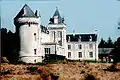
.jpg.webp) The chateau of Villers-Châtel | |
 Coat of arms | |
Location of Villers-Châtel | |
 Villers-Châtel  Villers-Châtel | |
| Coordinates: 50°22′38″N 2°35′17″E | |
| Country | France |
| Region | Hauts-de-France |
| Department | Pas-de-Calais |
| Arrondissement | Arras |
| Canton | Avesnes-le-Comte |
| Intercommunality | CC Campagnes de l'Artois |
| Government | |
| • Mayor (2020–2026) | Denise Tetelin[1] |
| Area 1 | 3.17 km2 (1.22 sq mi) |
| Population | 130 |
| • Density | 41/km2 (110/sq mi) |
| Time zone | UTC+01:00 (CET) |
| • Summer (DST) | UTC+02:00 (CEST) |
| INSEE/Postal code | 62857 /62690 |
| Elevation | 111–159 m (364–522 ft) (avg. 147 m or 482 ft) |
| 1 French Land Register data, which excludes lakes, ponds, glaciers > 1 km2 (0.386 sq mi or 247 acres) and river estuaries. | |
Geography
Villers-Châtel is situated some 13 miles (21 km) northwest of Arras, at the junction of the D73E road.
Population
| Year | Pop. | ±% p.a. |
|---|---|---|
| 1968 | 106 | — |
| 1975 | 76 | −4.64% |
| 1982 | 92 | +2.77% |
| 1990 | 115 | +2.83% |
| 1999 | 123 | +0.75% |
| 2007 | 118 | −0.52% |
| 2012 | 133 | +2.42% |
| 2017 | 135 | +0.30% |
| Source: INSEE[4] | ||
Places of interest
- The chateau, dating from the fourteenth century.
References
- "Répertoire national des élus: les maires" (in French). data.gouv.fr, Plateforme ouverte des données publiques françaises. 13 September 2022.
- "Populations légales 2020". The National Institute of Statistics and Economic Studies. 29 December 2022.
- INSEE commune file
- Population en historique depuis 1968, INSEE
Wikimedia Commons has media related to Villers-Châtel.
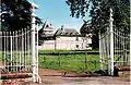
.jpg.webp)
This article is issued from Wikipedia. The text is licensed under Creative Commons - Attribution - Sharealike. Additional terms may apply for the media files.