Bourlon
Bourlon (French pronunciation: [buʁlɔ̃]) is a commune in the Pas-de-Calais department in the Hauts-de-France region in northern France.[3]
Bourlon | |
|---|---|
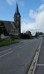 The church of Bourlon | |
 Coat of arms | |
Location of Bourlon | |
 Bourlon  Bourlon | |
| Coordinates: 50°10′43″N 3°07′03″E | |
| Country | France |
| Region | Hauts-de-France |
| Department | Pas-de-Calais |
| Arrondissement | Arras |
| Canton | Bapaume |
| Intercommunality | CC Osartis Marquion |
| Government | |
| • Mayor (2020–2026) | Jean-Luc Boyer[1] |
| Area 1 | 12.3 km2 (4.7 sq mi) |
| Population | 1,133 |
| • Density | 92/km2 (240/sq mi) |
| Time zone | UTC+01:00 (CET) |
| • Summer (DST) | UTC+02:00 (CEST) |
| INSEE/Postal code | 62164 /62860 |
| Elevation | 53–127 m (174–417 ft) (avg. 80 m or 260 ft) |
| 1 French Land Register data, which excludes lakes, ponds, glaciers > 1 km2 (0.386 sq mi or 247 acres) and river estuaries. | |
Geography
A farming village located 22 miles (35 km) southeast of Arras on the D16 road, just yards from the A26 autoroute.
Population
| Year | Pop. | ±% |
|---|---|---|
| 1962 | 1,120 | — |
| 1968 | 1,123 | +0.3% |
| 1975 | 1,065 | −5.2% |
| 1982 | 1,135 | +6.6% |
| 1990 | 1,212 | +6.8% |
| 1999 | 1,246 | +2.8% |
| 2009 | 1,203 | −3.5% |
Sights
- The Canadian Bourlon Wood Memorial war memorial.
- The church of St. Martin, dating from the eighteenth century.
- Two 20th century chapels.
- The Commonwealth War Graves Commission cemetery.
References
- "Répertoire national des élus: les maires". data.gouv.fr, Plateforme ouverte des données publiques françaises (in French). 2 December 2020.
- "Populations légales 2020". The National Institute of Statistics and Economic Studies. 29 December 2022.
- INSEE commune file
This article is issued from Wikipedia. The text is licensed under Creative Commons - Attribution - Sharealike. Additional terms may apply for the media files.