Mercatel
Mercatel (French pronunciation: [mɛʁkatɛl]) is a commune in the Pas-de-Calais department in the Hauts-de-France region of France.[3]
Mercatel | |
|---|---|
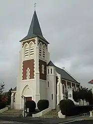 The church of Mercatel | |
 Coat of arms | |
Location of Mercatel | |
 Mercatel  Mercatel | |
| Coordinates: 50°14′10″N 2°47′47″E | |
| Country | France |
| Region | Hauts-de-France |
| Department | Pas-de-Calais |
| Arrondissement | Arras |
| Canton | Arras-3 |
| Intercommunality | CU d'Arras |
| Government | |
| • Mayor (2020–2026) | Sylvain Roy[1] |
| Area 1 | 5.76 km2 (2.22 sq mi) |
| Population | 726 |
| • Density | 130/km2 (330/sq mi) |
| Time zone | UTC+01:00 (CET) |
| • Summer (DST) | UTC+02:00 (CEST) |
| INSEE/Postal code | 62568 /62217 |
| Elevation | 71–99 m (233–325 ft) (avg. 88 m or 289 ft) |
| 1 French Land Register data, which excludes lakes, ponds, glaciers > 1 km2 (0.386 sq mi or 247 acres) and river estuaries. | |
Geography
Mercatel is situated 4 miles (6 km) south of Arras, at the junction of the D34 and the N17 roads.
Population
| Year | Pop. | ±% p.a. |
|---|---|---|
| 1968 | 446 | — |
| 1975 | 526 | +2.38% |
| 1982 | 515 | −0.30% |
| 1990 | 546 | +0.73% |
| 1999 | 572 | +0.52% |
| 2007 | 628 | +1.17% |
| 2012 | 611 | −0.55% |
| 2017 | 697 | +2.67% |
| Source: INSEE[4] | ||
Places of interest
- The church of St.Leger, rebuilt, as was most of the village, after the First World War.
- The Commonwealth War Graves Commission cemetery.
References
- "Répertoire national des élus: les maires". data.gouv.fr, Plateforme ouverte des données publiques françaises (in French). 9 August 2021.
- "Populations légales 2020". The National Institute of Statistics and Economic Studies. 29 December 2022.
- INSEE commune file
- Population en historique depuis 1968, INSEE
This article is issued from Wikipedia. The text is licensed under Creative Commons - Attribution - Sharealike. Additional terms may apply for the media files.