Eps, Pas-de-Calais
Eps is a commune in the Pas-de-Calais department in the Hauts-de-France region of France.[3]
Eps | |
|---|---|
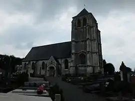 The church of Eps | |
 Coat of arms | |
Location of Eps | |
 Eps  Eps | |
| Coordinates: 50°27′20″N 2°17′48″E | |
| Country | France |
| Region | Hauts-de-France |
| Department | Pas-de-Calais |
| Arrondissement | Arras |
| Canton | Saint-Pol-sur-Ternoise |
| Intercommunality | CC Ternois |
| Government | |
| • Mayor (2020–2026) | Philippe Mayeur[1] |
| Area 1 | 6.87 km2 (2.65 sq mi) |
| Population | 246 |
| • Density | 36/km2 (93/sq mi) |
| Time zone | UTC+01:00 (CET) |
| • Summer (DST) | UTC+02:00 (CEST) |
| INSEE/Postal code | 62299 /62134 |
| Elevation | 59–155 m (194–509 ft) (avg. 76 m or 249 ft) |
| 1 French Land Register data, which excludes lakes, ponds, glaciers > 1 km2 (0.386 sq mi or 247 acres) and river estuaries. | |
Geography
A farming village situated 27 miles (43 km) northwest of Arras at the junction of the D70 and D71 roads.
Places of interest
- The church of St. Martin, dating from the sixteenth century.
References
- "Répertoire national des élus: les maires". data.gouv.fr, Plateforme ouverte des données publiques françaises (in French). 9 August 2021.
- "Populations légales 2020". The National Institute of Statistics and Economic Studies. 29 December 2022.
- INSEE commune file
External links
Wikimedia Commons has media related to Eps.
- Eps on the Quid website (in French)
This article is issued from Wikipedia. The text is licensed under Creative Commons - Attribution - Sharealike. Additional terms may apply for the media files.