Blairville, Pas-de-Calais
Blairville (French pronunciation: [blɛʁvil]) is a commune in the Pas-de-Calais department in the Hauts-de-France region in northern France.[3]
Blairville | |
|---|---|
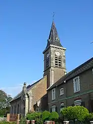 The church of Blairville | |
 Coat of arms | |
Location of Blairville | |
 Blairville  Blairville | |
| Coordinates: 50°13′14″N 2°42′53″E | |
| Country | France |
| Region | Hauts-de-France |
| Department | Pas-de-Calais |
| Arrondissement | Arras |
| Canton | Avesnes-le-Comte |
| Intercommunality | CC Campagnes de l'Artois |
| Government | |
| • Mayor (2020–2026) | Dominique Coppin[1] |
| Area 1 | 4.6 km2 (1.8 sq mi) |
| Population | 307 |
| • Density | 67/km2 (170/sq mi) |
| Time zone | UTC+01:00 (CET) |
| • Summer (DST) | UTC+02:00 (CEST) |
| INSEE/Postal code | 62135 /62173 |
| Elevation | 91–130 m (299–427 ft) (avg. 115 m or 377 ft) |
| 1 French Land Register data, which excludes lakes, ponds, glaciers > 1 km2 (0.386 sq mi or 247 acres) and river estuaries. | |
Geography
A farming village located 8 miles (13 km) southwest of Arras on the D34 road.
Population
| Year | Pop. | ±% |
|---|---|---|
| 1962 | 240 | — |
| 1968 | 247 | +2.9% |
| 1975 | 269 | +8.9% |
| 1982 | 265 | −1.5% |
| 1990 | 271 | +2.3% |
| 1999 | 298 | +10.0% |
| 2006 | 309 | +3.7% |
| 2009 | 300 | −2.9% |
| 2011 | 296 | −1.3% |
| 2015 | 307 | +3.7% |
Sights
- The church of St. Vaast, which, like most of the village, was rebuilt after the ravages of World War I.
References
- "Répertoire national des élus: les maires". data.gouv.fr, Plateforme ouverte des données publiques françaises (in French). 9 August 2021.
- "Populations légales 2020". The National Institute of Statistics and Economic Studies. 29 December 2022.
- INSEE commune file
Wikimedia Commons has media related to Blairville.
This article is issued from Wikipedia. The text is licensed under Creative Commons - Attribution - Sharealike. Additional terms may apply for the media files.