Saint-Sorlin-en-Valloire
Saint-Sorlin-en-Valloire is a commune in the Drôme department in southeastern France.
Saint-Sorlin-en-Valloire | |
|---|---|
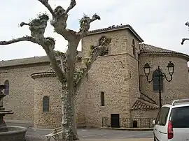 The church of Saint Saturnin, in Saint-Sorlin-en-Valloire | |
.svg.png.webp) Coat of arms | |
Location of Saint-Sorlin-en-Valloire | |
 Saint-Sorlin-en-Valloire  Saint-Sorlin-en-Valloire | |
| Coordinates: 45°17′N 4°57′E | |
| Country | France |
| Region | Auvergne-Rhône-Alpes |
| Department | Drôme |
| Arrondissement | Valence |
| Canton | Drôme des collines |
| Government | |
| • Mayor (2020–2026) | Guillaume Luyton[1] |
| Area 1 | 26.50 km2 (10.23 sq mi) |
| Population | 2,247 |
| • Density | 85/km2 (220/sq mi) |
| Time zone | UTC+01:00 (CET) |
| • Summer (DST) | UTC+02:00 (CEST) |
| INSEE/Postal code | 26330 /26210 |
| Elevation | 199–413 m (653–1,355 ft) (avg. 150 m or 490 ft) |
| 1 French Land Register data, which excludes lakes, ponds, glaciers > 1 km2 (0.386 sq mi or 247 acres) and river estuaries. | |
Population
| Year | Pop. | ±% p.a. |
|---|---|---|
| 1968 | 1,349 | — |
| 1975 | 1,376 | +0.28% |
| 1982 | 1,403 | +0.28% |
| 1990 | 1,452 | +0.43% |
| 1999 | 1,559 | +0.79% |
| 2007 | 1,878 | +2.35% |
| 2012 | 2,197 | +3.19% |
| 2017 | 2,268 | +0.64% |
| Source: INSEE[3] | ||
See also
References
- "Répertoire national des élus: les maires". data.gouv.fr, Plateforme ouverte des données publiques françaises (in French). 9 August 2021.
- "Populations légales 2020". The National Institute of Statistics and Economic Studies. 29 December 2022.
- Population en historique depuis 1968, INSEE
Wikimedia Commons has media related to Saint-Sorlin-en-Valloire.
This article is issued from Wikipedia. The text is licensed under Creative Commons - Attribution - Sharealike. Additional terms may apply for the media files.