Buis-les-Baronnies
Buis-les-Baronnies (French pronunciation: [bɥi le baʁɔni]; Vivaro-Alpine: Lo Bois dei Baroniás) is a commune in the Drôme department in the Auvergne-Rhône-Alpes region in Southeastern France. In 2019, it had a population of 2,325.
Buis-les-Baronnies | |
|---|---|
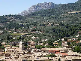 A general view of Buis-les-Baronnies | |
 Coat of arms | |
Location of Buis-les-Baronnies | |
 Buis-les-Baronnies  Buis-les-Baronnies | |
| Coordinates: 44°16′35″N 5°16′31″E | |
| Country | France |
| Region | Auvergne-Rhône-Alpes |
| Department | Drôme |
| Arrondissement | Nyons |
| Canton | Nyons et Baronnies |
| Government | |
| • Mayor (2020–2026) | Sébastien Bernard[1] |
| Area 1 | 33.74 km2 (13.03 sq mi) |
| Population | 2,291 |
| • Density | 68/km2 (180/sq mi) |
| Time zone | UTC+01:00 (CET) |
| • Summer (DST) | UTC+02:00 (CEST) |
| INSEE/Postal code | 26063 /26170 |
| Elevation | 319–1,080 m (1,047–3,543 ft) (avg. 370 m or 1,210 ft) |
| 1 French Land Register data, which excludes lakes, ponds, glaciers > 1 km2 (0.386 sq mi or 247 acres) and river estuaries. | |
Geography
Buis-les-Baronnies is located on the right bank of the river Ouvèze (Buis-les-Baronnies as a town has limits on the other bank).
Demographics
| Year | Pop. | ±% p.a. |
|---|---|---|
| 1946 | 1,333 | — |
| 1954 | 1,383 | +0.46% |
| 1962 | 1,496 | +0.99% |
| 1968 | 1,602 | +1.15% |
| 1975 | 1,729 | +1.10% |
| 1982 | 1,885 | +1.24% |
| 1990 | 2,030 | +0.93% |
| 1999 | 2,226 | +1.03% |
| 2007 | 2,290 | +0.35% |
| 2012 | 2,257 | −0.29% |
| 2017 | 2,302 | +0.40% |
| 2020 | 2,291 | −0.16% |
| Source: INSEE[3] | ||
References
- "Répertoire national des élus: les maires". data.gouv.fr, Plateforme ouverte des données publiques françaises (in French). 2 December 2020.
- "Populations légales 2020". The National Institute of Statistics and Economic Studies. 29 December 2022.
- Population en historique depuis 1968, INSEE
Wikimedia Commons has media related to Buis-les-Baronnies.
This article is issued from Wikipedia. The text is licensed under Creative Commons - Attribution - Sharealike. Additional terms may apply for the media files.