Montferrand-la-Fare
Montferrand-la-Fare (French pronunciation: [mɔ̃fɛʁɑ̃ la faʁ]; Occitan: Montferrand e La Fara) is a commune in the Drôme department in southeastern France.
Montferrand-la-Fare | |
|---|---|
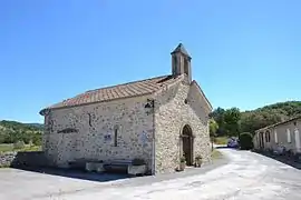 The church in Montferrand-la-Fare | |
Location of Montferrand-la-Fare | |
 Montferrand-la-Fare  Montferrand-la-Fare | |
| Coordinates: 44°21′39″N 5°27′01″E | |
| Country | France |
| Region | Auvergne-Rhône-Alpes |
| Department | Drôme |
| Arrondissement | Nyons |
| Canton | Nyons et Baronnies |
| Government | |
| • Mayor (2020–2026) | Sylvie Garnero[1] |
| Area 1 | 11.24 km2 (4.34 sq mi) |
| Population | 28 |
| • Density | 2.5/km2 (6.5/sq mi) |
| Time zone | UTC+01:00 (CET) |
| • Summer (DST) | UTC+02:00 (CEST) |
| INSEE/Postal code | 26199 /26510 |
| Elevation | 546–1,392 m (1,791–4,567 ft) |
| 1 French Land Register data, which excludes lakes, ponds, glaciers > 1 km2 (0.386 sq mi or 247 acres) and river estuaries. | |
Population
| Year | Pop. | ±% |
|---|---|---|
| 1911 | 96 | — |
| 1962 | 41 | −57.3% |
| 1968 | 43 | +4.9% |
| 1975 | 46 | +7.0% |
| 1982 | 35 | −23.9% |
| 1990 | 32 | −8.6% |
| 1999 | 46 | +43.8% |
| 2008 | 54 | +17.4% |
See also
References
- "Répertoire national des élus: les maires" (in French). data.gouv.fr, Plateforme ouverte des données publiques françaises. 13 September 2022.
- "Populations légales 2020". The National Institute of Statistics and Economic Studies. 29 December 2022.
Wikimedia Commons has media related to Montferrand-la-Fare.
This article is issued from Wikipedia. The text is licensed under Creative Commons - Attribution - Sharealike. Additional terms may apply for the media files.