Eyzahut
Eyzahut (French pronunciation: [eza.y]) is a commune in the Drôme department in the Auvergne-Rhône-Alpes region in southeastern France. It is a rather touristic spot of the area in the summer, thanks to the natural scenery surrounding it and infrastructures built in the 1970s (public swimming pool, tennis court).
Eyzahut | |
|---|---|
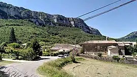 A general view of Eyzahut | |
Location of Eyzahut | |
 Eyzahut  Eyzahut | |
| Coordinates: 44°33′57″N 5°00′45″E | |
| Country | France |
| Region | Auvergne-Rhône-Alpes |
| Department | Drôme |
| Arrondissement | Nyons |
| Canton | Dieulefit |
| Government | |
| • Mayor (2020–2026) | Fabienne Simian[1] |
| Area 1 | 6.66 km2 (2.57 sq mi) |
| Population | 151 |
| • Density | 23/km2 (59/sq mi) |
| Time zone | UTC+01:00 (CET) |
| • Summer (DST) | UTC+02:00 (CEST) |
| INSEE/Postal code | 26131 /26160 |
| Elevation | 285–872 m (935–2,861 ft) |
| Website | http://www.eyzahut.fr/ |
| 1 French Land Register data, which excludes lakes, ponds, glaciers > 1 km2 (0.386 sq mi or 247 acres) and river estuaries. | |
Population
| Year | Pop. | ±% |
|---|---|---|
| 1911 | 133 | — |
| 1962 | 63 | −52.6% |
| 1968 | 52 | −17.5% |
| 1975 | 47 | −9.6% |
| 1982 | 78 | +66.0% |
| 1990 | 86 | +10.3% |
| 1999 | 111 | +29.1% |
| 2008 | 129 | +16.2% |
See also
References
- "Répertoire national des élus: les maires". data.gouv.fr, Plateforme ouverte des données publiques françaises (in French). 2 December 2020.
- "Populations légales 2020". The National Institute of Statistics and Economic Studies. 29 December 2022.
Wikimedia Commons has media related to Eyzahut.
This article is issued from Wikipedia. The text is licensed under Creative Commons - Attribution - Sharealike. Additional terms may apply for the media files.