Saint-May
Saint-May (French pronunciation: [sɛ̃ mɛ]; Occitan: Sant Mai) is a commune in the Drôme department in southeastern France.
Saint-May | |
|---|---|
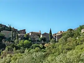 A general view of Saint-May | |
.svg.png.webp) Coat of arms | |
Location of Saint-May | |
 Saint-May  Saint-May | |
| Coordinates: 44°25′37″N 5°19′08″E | |
| Country | France |
| Region | Auvergne-Rhône-Alpes |
| Department | Drôme |
| Arrondissement | Nyons |
| Canton | Nyons et Baronnies |
| Government | |
| • Mayor (2020–2026) | Alain Labrot[1] |
| Area 1 | 10.23 km2 (3.95 sq mi) |
| Population | 33 |
| • Density | 3.2/km2 (8.4/sq mi) |
| Time zone | UTC+01:00 (CET) |
| • Summer (DST) | UTC+02:00 (CEST) |
| INSEE/Postal code | 26318 /26510 |
| Elevation | 382–1,173 m (1,253–3,848 ft) (avg. 415 m or 1,362 ft) |
| 1 French Land Register data, which excludes lakes, ponds, glaciers > 1 km2 (0.386 sq mi or 247 acres) and river estuaries. | |
Population
| Year | Pop. | ±% |
|---|---|---|
| 1911 | 138 | — |
| 1962 | 36 | −73.9% |
| 1968 | 49 | +36.1% |
| 1975 | 42 | −14.3% |
| 1982 | 49 | +16.7% |
| 1990 | 44 | −10.2% |
| 1999 | 41 | −6.8% |
| 2008 | 45 | +9.8% |
See also
References
- "Répertoire national des élus: les maires". data.gouv.fr, Plateforme ouverte des données publiques françaises (in French). 9 August 2021.
- "Populations légales 2020". The National Institute of Statistics and Economic Studies. 29 December 2022.
Wikimedia Commons has media related to Saint-May.
This article is issued from Wikipedia. The text is licensed under Creative Commons - Attribution - Sharealike. Additional terms may apply for the media files.