Mairjimmy, New South Wales
Mairjimmy is a rural community in the central south part of the Riverina. It is situated by road, about 17 kilometres south east of Jerilderie and 20 kilometres north west of Berrigan.
| Mairjimmy New South Wales | |
|---|---|
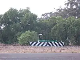 Intersection near former rail siding | |
 Mairjimmy | |
| Coordinates | 35°29′36″S 145°44′36″E |
| Population | 37 (SAL 2021)[1] |
| Postcode(s) | 2712 |
| Elevation | 114 m (374 ft) |
| Location |
|
| LGA(s) | Murrumbidgee Council |
| County | Urana |
| State electorate(s) | Albury |
| Federal division(s) | Farrer |
Mairjimmy Football Club entered the Southern Riverina Football Association for one season only in 1917.[2]
References
- Australian Bureau of Statistics (28 June 2022). "Mairjimmy (Suburb and Locality)". Australian Census 2021 QuickStats. Retrieved 28 June 2022.
- "1917 - Southern Riverina FA - AGM". Tocumwal Guardian & Riverina Echo. 29 June 1917. p. 2. Retrieved 30 May 2020 – via Trove Newspapers.
External links
![]() Media related to Mairjimmy, New South Wales at Wikimedia Commons
Media related to Mairjimmy, New South Wales at Wikimedia Commons
This article is issued from Wikipedia. The text is licensed under Creative Commons - Attribution - Sharealike. Additional terms may apply for the media files.