Gogeldrie, New South Wales
Gogeldrie is a town community in the central north part of the Riverina and situated about 11 kilometres west of Leeton and 11 kilometres east of Whitton. At the 2021 census, Gogeldrie had a population of 65 people.[1]
| Gogeldrie New South Wales | |
|---|---|
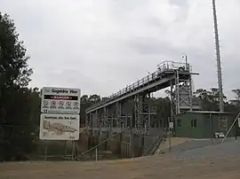 Gogeldrie Weir | |
 Gogeldrie | |
| Coordinates | 34°33′20″S 146°16′58″E |
| Population | 65 (2021 census)[1] |
| Postcode(s) | 2705 |
| Elevation | 148 m (486 ft) |
| Location | |
| LGA(s) | Leeton Shire |
| County | Cooper |
| State electorate(s) | Murray |
| Federal division(s) | Riverina |
Gogeldrie Post Office opened on 15 May 1933 and closed in 1945.[2]
Notes and references
- Australian Bureau of Statistics (28 June 2022). "Gogeldrie (State Suburb)". 2021 Census QuickStats. Retrieved 18 March 2023.
- Premier Postal History, Post Office List, retrieved 11 June 2009
| Preceding station | Former Services | Following station | ||
|---|---|---|---|---|
| Whitton towards Hay |
Hay Line | Yanco towards Junee | ||
Wikimedia Commons has media related to Gogeldrie, New South Wales.
This article is issued from Wikipedia. The text is licensed under Creative Commons - Attribution - Sharealike. Additional terms may apply for the media files.