Whitewater Township, Hamilton County, Ohio
Whitewater Township is one of the twelve townships of Hamilton County, Ohio, United States. The population was 6,375 as of the 2020 census.
Whitewater Township, Hamilton County, Ohio | |
|---|---|
 Countryside along U.S. Route 50 | |
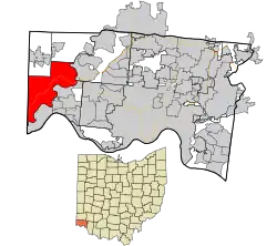 Location in Hamilton County and the state of Ohio. | |
| Coordinates: 39°11′50″N 84°45′51″W | |
| Country | United States |
| State | Ohio |
| County | Hamilton |
| Area | |
| • Total | 26.3 sq mi (68.2 km2) |
| • Land | 25.4 sq mi (65.7 km2) |
| • Water | 1.0 sq mi (2.6 km2) |
| Elevation | 509 ft (155 m) |
| Population (2020) | |
| • Total | 6,375[2] |
| Time zone | UTC-5 (Eastern (EST)) |
| • Summer (DST) | UTC-4 (EDT) |
| FIPS code | 39-84938[3] |
| GNIS feature ID | 1086235[1] |
| Website | www |
Geography
Located in the western part of the county, it borders the following townships:
- Harrison Township - north
- Crosby Township - northeast, west of Colerain Township
- Colerain Township - northeast, east of Crosby Township
- Miami Township - southeast
- Lawrenceburg Township, Dearborn County, Indiana - southwest
- Miller Township, Dearborn County, Indiana - west
- Harrison Township, Dearborn County, Indiana - northwest corner
No municipalities are located in Whitewater Township, although four unincorporated census-designated places lie in the township: Elizabethtown in the southwest, Hooven in the southeast, Blue Jay in the north, and Miamitown in the east.
Name and history
It is the only Whitewater Township statewide.[4]
Government
The township is governed by a three-member board of trustees, who are elected in November of odd-numbered years to a four-year term beginning on the following January 1. Two are elected in the year after the presidential election and one is elected in the year before it. There is also an elected township fiscal officer,[5] who serves a four-year term beginning on April 1 of the year after the election, which is held in November of the year before the presidential election. Vacancies in the fiscal officership or on the board of trustees are filled by the remaining trustees.
See also
References
- "US Board on Geographic Names". United States Geological Survey. October 25, 2007. Retrieved January 31, 2008.
- "Whitewater township, Hamilton County, Ohio - Census Bureau Profile". United States Census Bureau. Retrieved March 6, 2023.
- "U.S. Census website". United States Census Bureau. Retrieved January 31, 2008.
- "Detailed map of Ohio" (PDF). United States Census Bureau. 2000. Retrieved February 16, 2007.
- §503.24, §505.01, and §507.01 of the Ohio Revised Code. Accessed 4/30/2009.
External links
Municipalities and communities of Hamilton County, Ohio, United States | ||
|---|---|---|
| Cities | 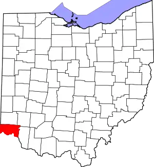 Map of Ohio highlighting Hamilton County | |
| Villages | ||
| Townships | ||
| CDPs |
| |
| Other communities | ||
| Footnotes | ‡This populated place also has portions in an adjacent county or counties | |