Shawnee, Hamilton County, Ohio
Shawnee is a census-designated place (CDP) in Miami Township, Hamilton County, Ohio, United States, 21 miles (34 km) west of downtown Cincinnati. The population of Shawnee was 747 at the 2020 census.
Shawnee, Ohio | |
|---|---|
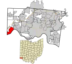 Location in Hamilton County and the state of Ohio | |
| Coordinates: 39°7′29″N 84°47′25″W | |
| Country | United States |
| State | Ohio |
| County | Hamilton |
| Area | |
| • Total | 6.94 sq mi (17.97 km2) |
| • Land | 6.42 sq mi (16.62 km2) |
| • Water | 0.52 sq mi (1.36 km2) |
| Elevation | 730 ft (220 m) |
| Population (2020) | |
| • Total | 747 |
| • Density | 116.41/sq mi (44.95/km2) |
| Time zone | UTC-5 (Eastern (EST)) |
| • Summer (DST) | UTC-4 (EDT) |
| FIPS code | 39-71958[3] |
Geography
Shawnee is located in the southwest corner of the state of Ohio, occupying the land between the Ohio and Great Miami rivers. To the south is Boone County, Kentucky, and to the west is Dearborn County, Indiana. To the north, across the Great Miami River, is Whitewater Township, and to the east are the villages of Cleves and North Bend. Much of the central heights of the CDP are taken up by Shawnee Lookout County Park. The area is also home to the Shawnee Lookout Archeological District.
Shawnee is located at 39°7′29″N 84°47′25″W.[4] According to the United States Census Bureau, the CDP has a total area of 6.9 square miles (18.0 km2), of which 6.4 square miles (16.6 km2) is land and 0.54 square miles (1.4 km2), or 7.63%, is water, consisting mainly of the Ohio and Great Miami rivers.[5]
References
- "ArcGIS REST Services Directory". United States Census Bureau. Retrieved September 20, 2022.
- "US Board on Geographic Names". United States Geological Survey. October 25, 2007. Retrieved January 31, 2008.
- "U.S. Census website". United States Census Bureau. Retrieved January 31, 2008.
- "US Gazetteer files: 2010, 2000, and 1990". United States Census Bureau. February 12, 2011. Retrieved April 23, 2011.
- "Geographic Identifiers: 2010 Demographic Profile Data (G001): Shawnee CDP, Ohio". U.S. Census Bureau, American Factfinder. Archived from the original on February 12, 2020. Retrieved November 15, 2012.
- "Census of Population and Housing". Census.gov. Retrieved June 4, 2016.
Municipalities and communities of Hamilton County, Ohio, United States | ||
|---|---|---|
| Cities | 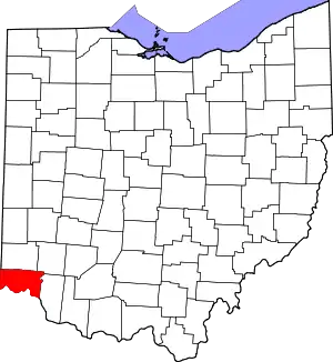 Map of Ohio highlighting Hamilton County | |
| Villages | ||
| Townships | ||
| CDPs |
| |
| Other communities | ||
| Footnotes | ‡This populated place also has portions in an adjacent county or counties | |