Colerain Township, Hamilton County, Ohio
Colerain Township is one of the twelve townships of Hamilton County, Ohio, United States. The population of the township was 59,037 at the 2020 census. It is the second-largest township in Ohio by area, surpassed by Madison Township, Lake County, Ohio.[4]
Colerain Township, Hamilton County, Ohio | |
|---|---|
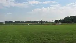 Fields at Fort Dunlap | |
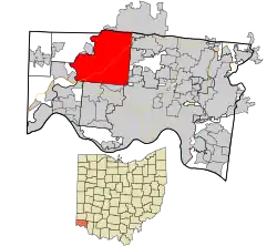 Location in Hamilton County and the state of Ohio. | |
| Coordinates: 39°14′54″N 84°35′57″W | |
| Country | United States |
| State | Ohio |
| County | Hamilton |
| Area | |
| • Total | 43.2 sq mi (111.8 km2) |
| • Land | 42.9 sq mi (111.0 km2) |
| • Water | 0.3 sq mi (0.9 km2) |
| Elevation | 853 ft (260 m) |
| Population (2020) | |
| • Total | 59,037[2] |
| Time zone | UTC-5 (Eastern (EST)) |
| • Summer (DST) | UTC-4 (EDT) |
| ZIP codes | 45239, 45247, 45251, 45252, 45253 (P.O. Boxes only), also a small part of 45231 |
| Area code | 513 |
| FIPS code | 39-16616[3] |
| GNIS feature ID | 1086202[1] |
| Website | www |
Geography
Located in the northern part of the county, it borders the following townships and cities:
- Ross Township, Butler County - north
- Fairfield - northeast
- Springfield Township - east
- Forest Park - east, between sections of Springfield Township
- Cincinnati - southeast
- Green Township - south
- Miami Township - southwest
- Whitewater Township - west
- Crosby Township - northwest
The only municipality in Colerain Township is a small part of the city of North College Hill in the far southeast, but ten census-designated places occupy most of the township in the east
- Dry Ridge, in the center, north of Northgate
- Dunlap, in the north
- Groesbeck, in the southeast, north of White Oak
- Mount Healthy Heights, in the northeast, south of Pleasant Run
- Northbrook, in the east
- Northgate, in the center
- Pleasant Run, in the northeast
- Skyline Acres, in the southeast, also in bordering Springfield Township
- Taylor Creek, in the southwest
- White Oak, in the southeast
The unincorporated communities of White Oak, Groesbeck, Northbrook, and Northgate are all within the township. White Oak is unique in its geography, in that it is part in Colerain Township and part in Green Township to the south.
The township is composed of 42.9 sq mi (111 km2) of gentle wooded hills separating the Mill Creek and Great Miami River basins, sloping down to the flood plain of the Miami. The terrain generally rises toward the north of the township. As of 1990, 29% of the township's land had been urbanized, and 15% developed as agricultural property, while half remained as woodlands. The township is crossed by Interstates 74 and 275, while the main north–south artery is Colerain Avenue (U.S. Route 27).
Name and history
Statewide, other Colerain Townships are located in Belmont and Ross counties. The village of Colerain was laid out in 1790 by surveyor John Dunlap, who was Scots-Irish and a native of the town Coleraine, in Londonderry County, Ireland (in what has since become Northern Ireland).[5] Fort Coleraine, aka Dunlap's Station, was one of the earliest attempts to settle the area despite the natives who had resided here for centuries without signing any land treaties.
The township was organized in 1794.
Government
The township is governed by a three-member board of trustees, who are elected in November of odd-numbered years to a four-year term beginning on the following January 1. Two are elected in the year after the presidential election and one is elected in the year before it. There is also an elected township fiscal officer,[6] who serves a four-year term beginning on April 1 of the year after the election, which is held in November of the year before the presidential election. Vacancies in the fiscal officership or on the board of trustees are filled by the remaining trustees.
Colerain Township has a sister city arrangement with Obergiesing, a suburb of the German city of Munich.
Recreation
References
- "US Board on Geographic Names". United States Geological Survey. October 25, 2007. Retrieved January 31, 2008.
- "DP05ACS DEMOGRAPHIC AND HOUSING ESTIMATES". United States Census Bureau. Retrieved March 3, 2023.
- "U.S. Census website". United States Census Bureau. Retrieved January 31, 2008.
- "Neighborhoods". Cincinnati magazine. Archived from the original on July 12, 2014. Retrieved July 25, 2014.
- Olden, J. G. (1882). Historical Sketches and Early Reminiscences of Hamilton County, Ohio. H. Watkin. p. 40.
- §503.24, §505.01, and §507.01 of the Ohio Revised Code. Accessed 4/30/2009.
External links
Municipalities and communities of Hamilton County, Ohio, United States | ||
|---|---|---|
| Cities | 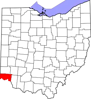 Map of Ohio highlighting Hamilton County | |
| Villages | ||
| Townships | ||
| CDPs |
| |
| Other communities | ||
| Footnotes | ‡This populated place also has portions in an adjacent county or counties | |