Kirrberg, Bas-Rhin
Kirrberg (French pronunciation: [kiʁbɛʁɡ]) is a commune in the northwest of the Bas-Rhin department in Grand Est in north-eastern France.[3] It lies 18 kilometres (11 mi) to the west of Phalsbourg.
Kirrberg | |
|---|---|
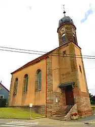 The Lutheran church in Kirrberg | |
.svg.png.webp) Coat of arms | |
Location of Kirrberg | |
 Kirrberg 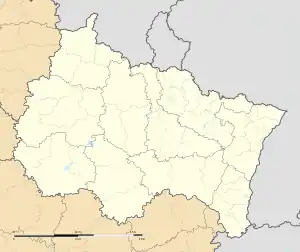 Kirrberg | |
| Coordinates: 48°49′23″N 7°03′54″E | |
| Country | France |
| Region | Grand Est |
| Department | Bas-Rhin |
| Arrondissement | Saverne |
| Canton | Ingwiller |
| Government | |
| • Mayor (2020–2026) | Jean-Marie Blaser[1] |
| Area 1 | 6.35 km2 (2.45 sq mi) |
| Population | 147 |
| • Density | 23/km2 (60/sq mi) |
| Time zone | UTC+01:00 (CET) |
| • Summer (DST) | UTC+02:00 (CEST) |
| INSEE/Postal code | 67241 /67320 |
| Elevation | 235–332 m (771–1,089 ft) |
| 1 French Land Register data, which excludes lakes, ponds, glaciers > 1 km2 (0.386 sq mi or 247 acres) and river estuaries. | |
History
The earliest surviving record, naming the village as Villa Teurino, dates from 512. The first appearance of a precursor to the present name occurs in 1501 with the name Kirpberg.
During the Thirty Years' War the village was almost entirely destroyed by fire.
See also
References
- "Répertoire national des élus: les maires" (in French). data.gouv.fr, Plateforme ouverte des données publiques françaises. 13 September 2022.
- "Populations légales 2020". The National Institute of Statistics and Economic Studies. 29 December 2022.
- INSEE commune file
Wikimedia Commons has media related to Kirrberg.
This article is issued from Wikipedia. The text is licensed under Creative Commons - Attribution - Sharealike. Additional terms may apply for the media files.