Berstett
Berstett is a commune in the Bas-Rhin department in Grand Est in northeastern France.[3]
Berstett
Barstett | |
|---|---|
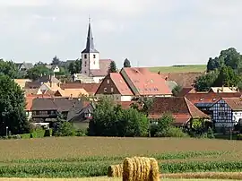 A general view of Berstett | |
 Coat of arms | |
Location of Berstett | |
 Berstett 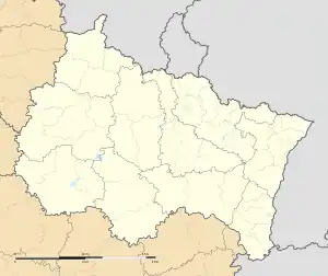 Berstett | |
| Coordinates: 48°40′48″N 7°39′31″E | |
| Country | France |
| Region | Grand Est |
| Department | Bas-Rhin |
| Arrondissement | Saverne |
| Canton | Bouxwiller |
| Intercommunality | CC Kochersberg |
| Government | |
| • Mayor (2020–2026) | Jean-Claude Lasthaus[1] |
| Area 1 | 17.88 km2 (6.90 sq mi) |
| Population | 2,462 |
| • Density | 140/km2 (360/sq mi) |
| Time zone | UTC+01:00 (CET) |
| • Summer (DST) | UTC+02:00 (CEST) |
| INSEE/Postal code | 67034 /67370 |
| Elevation | 147–281 m (482–922 ft) |
| 1 French Land Register data, which excludes lakes, ponds, glaciers > 1 km2 (0.386 sq mi or 247 acres) and river estuaries. | |
In 1972, the communes of Berstett, Gimbrett, Reitwiller (German: Reitweiler) and Rumersheim were merged into the present commune.
Population
| Year | Pop. | ±% |
|---|---|---|
| 1962 | 1,261 | — |
| 1968 | 1,265 | +0.3% |
| 1975 | 1,274 | +0.7% |
| 1982 | 1,527 | +19.9% |
| 1990 | 1,679 | +10.0% |
| 1999 | 1,919 | +14.3% |
| 2006 | 2,053 | +7.0% |
| 2009 | 2,287 | +11.4% |
References
- "Répertoire national des élus: les maires". data.gouv.fr, Plateforme ouverte des données publiques françaises (in French). 2 December 2020.
- "Populations légales 2020". The National Institute of Statistics and Economic Studies. 29 December 2022.
- INSEE commune file
External links
Wikimedia Commons has media related to Berstett.
This article is issued from Wikipedia. The text is licensed under Creative Commons - Attribution - Sharealike. Additional terms may apply for the media files.