Durningen
Durningen (French pronunciation: [dyʁniŋ(ɡ)ən] ⓘ; Dürningen in German; Dírnínge in Alsatian) is a commune in the Bas-Rhin department and Grand Est region of north-eastern France.[3]
Durningen
Dírnínge | |
|---|---|
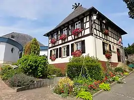 The town hall in Durningen | |
.svg.png.webp) Coat of arms | |
Location of Durningen | |
 Durningen 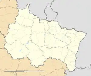 Durningen | |
| Coordinates: 48°41′02″N 7°34′05″E | |
| Country | France |
| Region | Grand Est |
| Department | Bas-Rhin |
| Arrondissement | Saverne |
| Canton | Bouxwiller |
| Intercommunality | CC Kochersberg |
| Government | |
| • Mayor (2020–2026) | Christine Blanchais[1] |
| Area 1 | 4.02 km2 (1.55 sq mi) |
| Population | 666 |
| • Density | 170/km2 (430/sq mi) |
| Time zone | UTC+01:00 (CET) |
| • Summer (DST) | UTC+02:00 (CEST) |
| INSEE/Postal code | 67109 /67270 |
| Elevation | 179–274 m (587–899 ft) |
| 1 French Land Register data, which excludes lakes, ponds, glaciers > 1 km2 (0.386 sq mi or 247 acres) and river estuaries. | |
It is the highest-situated commune in the Kochersberg natural region.
The name is first recorded in 724 as Deorangus, subsequently as Teuringas (742), Thurinca (787), Thuringen (1276), and finally Turningen / Durningen (1371).
In the Middle Ages, Durningen was part of the domain of Hanau-Lichtenberg and belonged to the Prince-Bishopric of Strasbourg.
See also
References
- "Répertoire national des élus: les maires". data.gouv.fr, Plateforme ouverte des données publiques françaises (in French). 9 August 2021.
- "Populations légales 2020". The National Institute of Statistics and Economic Studies. 29 December 2022.
- INSEE commune file
External links
Wikimedia Commons has media related to Durningen.
This article is issued from Wikipedia. The text is licensed under Creative Commons - Attribution - Sharealike. Additional terms may apply for the media files.