Saint-Urcize
Saint-Urcize (French pronunciation: [sɛ̃.t‿yʁsiz]; Occitan: Sant Urcise) is a commune in the Cantal department in south-central France.
Saint-Urcize | |
|---|---|
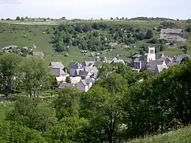 A general view of Saint-Urcize | |
 Coat of arms | |
Location of Saint-Urcize | |
 Saint-Urcize  Saint-Urcize | |
| Coordinates: 44°41′51″N 3°00′17″E | |
| Country | France |
| Region | Auvergne-Rhône-Alpes |
| Department | Cantal |
| Arrondissement | Saint-Flour |
| Canton | Neuvéglise-sur-Truyère |
| Government | |
| • Mayor (2020–2026) | Bernard Remise[1] |
| Area 1 | 54.3 km2 (21.0 sq mi) |
| Population | 398 |
| • Density | 7.3/km2 (19/sq mi) |
| Time zone | UTC+01:00 (CET) |
| • Summer (DST) | UTC+02:00 (CEST) |
| INSEE/Postal code | 15216 /15110 |
| Elevation | 1,044–1,427 m (3,425–4,682 ft) (avg. 1,120 m or 3,670 ft) |
| 1 French Land Register data, which excludes lakes, ponds, glaciers > 1 km2 (0.386 sq mi or 247 acres) and river estuaries. | |
Population
| Year | Pop. | ±% |
|---|---|---|
| 1962 | 733 | — |
| 1968 | 654 | −10.8% |
| 1975 | 652 | −0.3% |
| 1982 | 510 | −21.8% |
| 1990 | 543 | +6.5% |
| 1999 | 527 | −2.9% |
| 2008 | 494 | −6.3% |
| 2016 | 447 | −9.5% |
See also
References
- "Répertoire national des élus: les maires". data.gouv.fr, Plateforme ouverte des données publiques françaises (in French). 2 December 2020.
- "Populations légales 2020". The National Institute of Statistics and Economic Studies. 29 December 2022.
Wikimedia Commons has media related to Saint-Urcize.
This article is issued from Wikipedia. The text is licensed under Creative Commons - Attribution - Sharealike. Additional terms may apply for the media files.