Laroquebrou
Laroquebrou (French pronunciation: [laʁɔk(ə)bʁu]; Occitan: La Ròcabrau) is a commune in the Cantal department in south-central France.
Laroquebrou | |
|---|---|
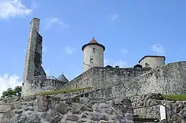 The Chateau de Laroquebrou | |
 Coat of arms | |
Location of Laroquebrou | |
 Laroquebrou  Laroquebrou | |
| Coordinates: 44°58′10″N 2°11′33″E | |
| Country | France |
| Region | Auvergne-Rhône-Alpes |
| Department | Cantal |
| Arrondissement | Aurillac |
| Canton | Saint-Paul-des-Landes |
| Government | |
| • Mayor (2020–2026) | Pascal Malvezin[1] |
| Area 1 | 17.15 km2 (6.62 sq mi) |
| Population | 804 |
| • Density | 47/km2 (120/sq mi) |
| Time zone | UTC+01:00 (CET) |
| • Summer (DST) | UTC+02:00 (CEST) |
| INSEE/Postal code | 15094 /15150 |
| Elevation | 429–693 m (1,407–2,274 ft) (avg. 440 m or 1,440 ft) |
| 1 French Land Register data, which excludes lakes, ponds, glaciers > 1 km2 (0.386 sq mi or 247 acres) and river estuaries. | |
Population
| Year | Pop. | ±% |
|---|---|---|
| 1962 | 1,237 | — |
| 1968 | 1,193 | −3.6% |
| 1975 | 1,014 | −15.0% |
| 1982 | 1,023 | +0.9% |
| 1990 | 1,048 | +2.4% |
| 1999 | 1,080 | +3.1% |
| 2008 | 929 | −14.0% |
See also
References
- "Répertoire national des élus: les maires" (in French). data.gouv.fr, Plateforme ouverte des données publiques françaises. 13 September 2022.
- "Populations légales 2020". The National Institute of Statistics and Economic Studies. 29 December 2022.
External links
![]() Media related to Laroquebrou at Wikimedia Commons
Media related to Laroquebrou at Wikimedia Commons
This article is issued from Wikipedia. The text is licensed under Creative Commons - Attribution - Sharealike. Additional terms may apply for the media files.