Saint-Santin-de-Maurs
Saint-Santin-de-Maurs (French pronunciation: [sɛ̃ sɑ̃tɛ̃ də mɔʁs], literally Saint-Santin of Maurs; Languedocien: Sant Santin de Maurs) is a commune in the Cantal department in south-central France.
Saint-Santin-de-Maurs | |
|---|---|
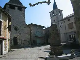 The two churches in Saint-Santin-de-Maurs | |
Location of Saint-Santin-de-Maurs | |
 Saint-Santin-de-Maurs  Saint-Santin-de-Maurs | |
| Coordinates: 44°39′06″N 2°13′01″E | |
| Country | France |
| Region | Auvergne-Rhône-Alpes |
| Department | Cantal |
| Arrondissement | Aurillac |
| Canton | Maurs |
| Government | |
| • Mayor (2020–2026) | Jean-Luc Broussal[1] |
| Area 1 | 14.52 km2 (5.61 sq mi) |
| Population | 361 |
| • Density | 25/km2 (64/sq mi) |
| Time zone | UTC+01:00 (CET) |
| • Summer (DST) | UTC+02:00 (CEST) |
| INSEE/Postal code | 15212 /15600 |
| Elevation | 233–487 m (764–1,598 ft) |
| 1 French Land Register data, which excludes lakes, ponds, glaciers > 1 km2 (0.386 sq mi or 247 acres) and river estuaries. | |
Since the French revolution, the town of Saint-Santin has been split in two communes in two different departments, Saint-Santin d'Aveyron in the department of Aveyron and Saint-Santin-de-Maurs.[3]
Population
| Year | Pop. | ±% |
|---|---|---|
| 1962 | 338 | — |
| 1968 | 382 | +13.0% |
| 1975 | 401 | +5.0% |
| 1982 | 407 | +1.5% |
| 1990 | 397 | −2.5% |
| 1999 | 340 | −14.4% |
| 2008 | 342 | +0.6% |
| 2016 | 357 | +4.4% |
See also
References
- "Répertoire national des élus: les maires". data.gouv.fr, Plateforme ouverte des données publiques françaises (in French). 2 December 2020.
- "Populations légales 2020". The National Institute of Statistics and Economic Studies. 29 December 2022.
- The village where everything comes in pairs, BBC
Wikimedia Commons has media related to Saint-Santin-de-Maurs.
This article is issued from Wikipedia. The text is licensed under Creative Commons - Attribution - Sharealike. Additional terms may apply for the media files.