Le May-sur-Èvre
Le May-sur-Èvre (French pronunciation: [lə mɛ syʁ ɛvʁ] ⓘ, literally Le May on Èvre) is a commune in the Maine-et-Loire department in western France. The population in 2018 was just under 4,000.
Le May-sur-Èvre | |
|---|---|
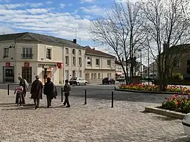 The town of Le-May-Sur-Evre | |
Location of Le May-sur-Èvre | |
 Le May-sur-Èvre  Le May-sur-Èvre | |
| Coordinates: 47°08′11″N 0°53′28″W | |
| Country | France |
| Region | Pays de la Loire |
| Department | Maine-et-Loire |
| Arrondissement | Cholet |
| Canton | Sèvremoine |
| Intercommunality | CA Choletais |
| Government | |
| • Mayor (2020–2026) | Alain Picard[1] |
| Area 1 | 31.85 km2 (12.30 sq mi) |
| Population | 3,827 |
| • Density | 120/km2 (310/sq mi) |
| Demonym(s) | Maytais, Maytaise |
| Time zone | UTC+01:00 (CET) |
| • Summer (DST) | UTC+02:00 (CEST) |
| INSEE/Postal code | 49193 /49122 |
| Elevation | 72–128 m (236–420 ft) |
| Website | Le May sur Evre, site officiel |
| 1 French Land Register data, which excludes lakes, ponds, glaciers > 1 km2 (0.386 sq mi or 247 acres) and river estuaries. | |
Geography
The commune is traversed by the Èvre river. It is around 10 km north of Cholet, and around 50 km east of Nantes.
References
- "Répertoire national des élus: les maires". data.gouv.fr, Plateforme ouverte des données publiques françaises (in French). 2 December 2020.
- "Populations légales 2020". The National Institute of Statistics and Economic Studies. 29 December 2022.
Wikimedia Commons has media related to Le May-sur-Èvre.
This article is issued from Wikipedia. The text is licensed under Creative Commons - Attribution - Sharealike. Additional terms may apply for the media files.