Durtal
Durtal (French pronunciation: [dyʁtal] ⓘ) is a commune in the Maine-et-Loire department in western France. It is around 32 km north-east of Angers the department capital.
Durtal | |
|---|---|
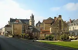 The centre of Durtal with the chateau | |
.svg.png.webp) Coat of arms | |
Location of Durtal | |
 Durtal  Durtal | |
| Coordinates: 47°40′22″N 0°14′24″W | |
| Country | France |
| Region | Pays de la Loire |
| Department | Maine-et-Loire |
| Arrondissement | Angers |
| Canton | Tiercé |
| Government | |
| • Mayor (2020–2026) | Pascal Farion[1] |
| Area 1 | 60.58 km2 (23.39 sq mi) |
| Population | 3,343 |
| • Density | 55/km2 (140/sq mi) |
| Time zone | UTC+01:00 (CET) |
| • Summer (DST) | UTC+02:00 (CEST) |
| INSEE/Postal code | 49127 /49430 |
| Elevation | 21–94 m (69–308 ft) (avg. 34 m or 112 ft) |
| 1 French Land Register data, which excludes lakes, ponds, glaciers > 1 km2 (0.386 sq mi or 247 acres) and river estuaries. | |
References
- "Répertoire national des élus: les maires". data.gouv.fr, Plateforme ouverte des données publiques françaises (in French). 2 December 2020.
- "Populations légales 2020". The National Institute of Statistics and Economic Studies. 29 December 2022.
Wikimedia Commons has media related to Durtal.
This article is issued from Wikipedia. The text is licensed under Creative Commons - Attribution - Sharealike. Additional terms may apply for the media files.