Armaillé
Armaillé (French pronunciation: [aʁmaje]) is a commune in the Maine-et-Loire department in western France.
Armaillé | |
|---|---|
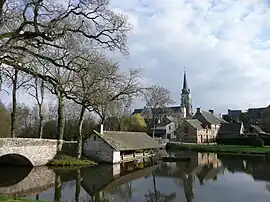 A general view of Armaillé | |
Location of Armaillé | |
 Armaillé  Armaillé | |
| Coordinates: 47°42′54″N 1°07′39″W | |
| Country | France |
| Region | Pays de la Loire |
| Department | Maine-et-Loire |
| Arrondissement | Segré |
| Canton | Segré-en-Anjou Bleu |
| Intercommunality | Anjou Bleu Communauté |
| Government | |
| • Mayor (2020–2026) | Emmanuelle Galisson[1] |
| Area 1 | 16.78 km2 (6.48 sq mi) |
| Population | 319 |
| • Density | 19/km2 (49/sq mi) |
| Time zone | UTC+01:00 (CET) |
| • Summer (DST) | UTC+02:00 (CEST) |
| INSEE/Postal code | 49010 /49420 |
| Elevation | 39–100 m (128–328 ft) (avg. 97 m or 318 ft) |
| 1 French Land Register data, which excludes lakes, ponds, glaciers > 1 km2 (0.386 sq mi or 247 acres) and river estuaries. | |
Geography
The village lies on the right bank of the Verzée, which flows east-southeast through the commune.
Population
|
|
References
- "Répertoire national des élus: les maires" (in French). data.gouv.fr, Plateforme ouverte des données publiques françaises. 13 September 2022.
- "Populations légales 2020". The National Institute of Statistics and Economic Studies. 29 December 2022.
Wikimedia Commons has media related to Armaillé.
This article is issued from Wikipedia. The text is licensed under Creative Commons - Attribution - Sharealike. Additional terms may apply for the media files.