Zahedan County
Zahedan County (Persian: شهرستان زاهدان) is in Sistan and Baluchestan province, Iran. Its capital is the city of Zahedan.
Zahedan County
Persian: شهرستان زاهدان | |
|---|---|
County | |
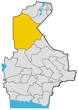 Location of Zahedan County in Sistan and Baluchestan province | |
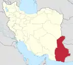
 Location of Sistan and Baluchestan province in Iran | |
| Coordinates: 29°37′45″N 60°20′50″E[1] | |
| Country | Iran |
| Province | Sistan and Baluchestan |
| Capital | Zahedan |
| Districts | Central, Kurin, Nosratabad |
| Population (2016)[2] | |
| • Total | 672,589 |
| Time zone | UTC+3:30 (IRST) |
| Zahedan County can be found at GEOnet Names Server, at this link, by opening the Advanced Search box, entering "9206427" in the "Unique Feature Id" form, and clicking on "Search Database". | |
At the 2006 census, the county's population was 663,822 in 130,763 households.[3] The following census in 2011 counted 660,575 people in 157,139 households.[4] At the 2016 census, the county's population was 672,589 in 168,480 households,[2] by which time Mirjaveh District had been separated from the county to form Mirjaveh County.[5]
Administrative divisions
The population history and structural changes of Zahedan County's administrative divisions over three consecutive censuses are shown in the following table. The latest census shows three districts, six rural districts, and two cities.[2]
| Administrative Divisions | 2006[3] | 2011[4] | 2016[2] |
|---|---|---|---|
| Central District | 577,898 | 587,156 | 628,219 |
| Cheshmeh Ziarat Rural District | 21,950 | 22,161 | 34,693 |
| Hormak Rural District | 3,242 | 4,270 | 5,796 |
| Zahedan (city) | 552,706 | 560,725 | 587,730 |
| Kurin District | 23,138 | 18,048 | 25,898 |
| Kurin Rural District | 15,885 | 12,264 | 17,764 |
| Shuru Rural District | 7,253 | 5,784 | 8,134 |
| Sar Jangal (city)1 | |||
| Mirjaveh District2 | 45,896 | 39,873 | |
| Ladiz Rural District | 23,953 | 21,712 | |
| Tamin Rural District | 8,353 | 8,040 | |
| Mirjaveh (city) | 13,590 | 10,121 | |
| Nosratabad District | 16,890 | 15,308 | 18,462 |
| Dumak Rural District | 6,746 | 4,581 | 5,437 |
| Nosratabad Rural District | 5,962 | 6,457 | 7,787 |
| Nosratabad (city) | 4,182 | 4,270 | 5,238 |
| Total | 663,822 | 660,575 | 672,589 |
| 1Became a city after the 2016 census[6] 2Became a part of Mirjaveh County[5] | |||
Wikimedia Commons has media related to Zahedan County.
References
- OpenStreetMap contributors (21 April 2023). "Zahedan County" (Map). OpenStreetMap. Retrieved 21 April 2023.
- "Census of the Islamic Republic of Iran, 1395 (2016)". AMAR (in Persian). The Statistical Center of Iran. p. 11. Archived from the original (Excel) on 23 December 2021. Retrieved 19 December 2022.
- "Census of the Islamic Republic of Iran, 1385 (2006)". AMAR (in Persian). The Statistical Center of Iran. p. 11. Archived from the original (Excel) on 20 September 2011. Retrieved 25 September 2022.
- "Census of the Islamic Republic of Iran, 1390 (2011)" (Excel). Iran Data Portal (in Persian). The Statistical Center of Iran. p. 11. Retrieved 19 December 2022.
- Rahimi, Mohammadreza. "Seven new counties were added to the map of country divisions". DOLAT (in Persian). Ministry of Interior, Board of Ministers. Archived from the original on 8 January 2013. Retrieved 10 April 2023.
- Fazli, Abdolreza Rahmani (21 September 2017). "Notification of the approval of the Ministry of Interior regarding the conversion of Sar Jangal village, the center of Kurin District of Zahedan County, into a city". Laws and Regulations Portal of Iran (in Persian). Ministry of Interior. Archived from the original on 29 January 2022. Retrieved 21 April 2023.
This article is issued from Wikipedia. The text is licensed under Creative Commons - Attribution - Sharealike. Additional terms may apply for the media files.