Nosratabad
Nosratabad (Persian: نصرت آباد, also Romanized as Noșratābād)[3] is a city in, and the capital of, Nosratabad District of Zahedan County, Sistan and Baluchestan province, Iran.
Nosratabad
Persian: نصرت آباد | |
|---|---|
City | |
 Nosratabad | |
| Coordinates: 29°51′29″N 59°58′45″E[1] | |
| Country | Iran |
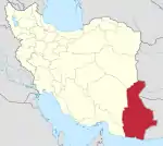
| Province | Sistan and Baluchestan |
| County | Zahedan |
| District | Nosratabad |
| Population (2016)[2] | |
| • Total | 5,238 |
| Time zone | UTC+3:30 (IRST) |
Nosratabad lies on the road from Zahedan to Bam.[4]
At the 2006 census, its population was 4,182 in 919 households.[5] The following census in 2011 counted 4,270 people in 931 households.[6] The latest census in 2016 showed a population of 5,238 people in 1,255 households.[2]
History
Nosratabad, the city of Nosrat, was named after Nusret el Mulk, a former deputy governor of Sistan; when built, c. 1870, it was first called Nasirabad in honour of Nasr-uddin Shah; other names, used locally, are Shahr-i-Seistan, Shahr-i-Nassiriyeh, or simply Shahr (the town). Its climate is very dry and hot; due to its location in the Lut Desert, it is among the hottest locations in the world. In August 1926, the highest officially recorded temperature soared to 58.0 °C.
During the late nineteenth century it was the residence of British and Russian consuls, and had post and telegraph offices (as of 1911). The city served as the capital of Sistan until some time in the 20th century.
The city was the site of a major explosion in 2004, when a fuel tanker lost control at a police checkpoint and collided with a bus, resulting in 90 fatalities and 114 additional injuries.[7]
On 3 June 2009, the Jondollah militant group blocked off roads between Nosratabad and Bam, seizing several trucks.[8]
- This article incorporates text from a publication now in the public domain: Chisholm, Hugh, ed. (1911). "Nusretabad". Encyclopædia Britannica (11th ed.). Cambridge University Press.
References
- OpenStreetMap contributors (22 April 2023). "Nosratabad, Zahedan County" (Map). OpenStreetMap. Retrieved 22 April 2023.
- "Census of the Islamic Republic of Iran, 1395 (2016)". AMAR (in Persian). The Statistical Center of Iran. p. 11. Archived from the original (Excel) on 23 December 2021. Retrieved 19 December 2022.
- Nosratabad can be found at GEOnet Names Server, at this link, by opening the Advanced Search box, entering "-3077107" in the "Unique Feature Id" form, and clicking on "Search Database".
- CNN.com - Iran tanker crash kills dozens - Jun 25, 2004
- "Census of the Islamic Republic of Iran, 1385 (2006)". AMAR (in Persian). The Statistical Center of Iran. p. 11. Archived from the original (Excel) on 20 September 2011. Retrieved 25 September 2022.
- "Census of the Islamic Republic of Iran, 1390 (2011)" (Excel). Iran Data Portal (in Persian). The Statistical Center of Iran. p. 11. Retrieved 19 December 2022.
- McDowall, Angus (25 June 2004). "Petrol tanker explosion kills 90 in Iran". The Independent. Retrieved 19 June 2023.
- Sunni rebel group takes claim for highway attack in Iran