Xuecheng District
Xuecheng (Chinese: 薛城区; pinyin: Xuēchéng Qū) is a district and the seat of Zaozhuang, Shandong province, China, ever named by "lin cheng ". It has an area of 506.72 km2 and around 405,285 inhabitants (2003).
Xuecheng District
薛城区 | |
|---|---|
 Location in Zaozhuang | |
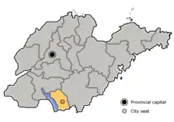 Zaozhuang in Shandong | |
| Coordinates: 34°46′28″N 117°15′05″E | |
| Country | People's Republic of China |
| Province | Shandong |
| Prefecture-level city | Zaozhuang |
| Area | |
| • Total | 423.02 km2 (163.33 sq mi) |
| Population (2016) | |
| • Total | 462,500 |
| • Density | 1,100/km2 (2,800/sq mi) |
| Time zone | UTC+8 (China Standard) |
| Postal code | 277000 |
Administrative divisions
As 2012, this district is divided to 3 subdistricts and 6 towns.[1]
- Subdistricts
- Lincheng Subdistrict (临城街道)
- Xingren Subdistrict (兴仁街道)
- Xingcheng Subdistrict (兴城街道)
- Towns
|
|
Climate
| Climate data for Xuecheng (1999–2020 normals, extremes 1981–2010) | |||||||||||||
|---|---|---|---|---|---|---|---|---|---|---|---|---|---|
| Month | Jan | Feb | Mar | Apr | May | Jun | Jul | Aug | Sep | Oct | Nov | Dec | Year |
| Record high °C (°F) | 16.7 (62.1) |
25.0 (77.0) |
28.2 (82.8) |
33.2 (91.8) |
37.9 (100.2) |
38.0 (100.4) |
39.9 (103.8) |
37.0 (98.6) |
35.5 (95.9) |
32.0 (89.6) |
25.9 (78.6) |
21.1 (70.0) |
39.9 (103.8) |
| Average high °C (°F) | 5.5 (41.9) |
8.8 (47.8) |
15.1 (59.2) |
21.4 (70.5) |
26.9 (80.4) |
30.9 (87.6) |
31.7 (89.1) |
30.8 (87.4) |
27.3 (81.1) |
21.7 (71.1) |
14.1 (57.4) |
7.1 (44.8) |
20.1 (68.2) |
| Daily mean °C (°F) | 1.2 (34.2) |
4.1 (39.4) |
9.9 (49.8) |
16.0 (60.8) |
21.6 (70.9) |
25.8 (78.4) |
27.4 (81.3) |
26.7 (80.1) |
22.7 (72.9) |
16.9 (62.4) |
9.6 (49.3) |
3.0 (37.4) |
15.4 (59.7) |
| Average low °C (°F) | −2.1 (28.2) |
0.5 (32.9) |
5.5 (41.9) |
11.3 (52.3) |
16.9 (62.4) |
21.4 (70.5) |
24.0 (75.2) |
23.4 (74.1) |
18.9 (66.0) |
12.9 (55.2) |
6.0 (42.8) |
−0.3 (31.5) |
11.5 (52.8) |
| Record low °C (°F) | −12.6 (9.3) |
−12.2 (10.0) |
−9.3 (15.3) |
−0.5 (31.1) |
4.7 (40.5) |
12.4 (54.3) |
16.5 (61.7) |
12.9 (55.2) |
6.8 (44.2) |
−1.0 (30.2) |
−8.5 (16.7) |
−12.4 (9.7) |
−12.6 (9.3) |
| Average precipitation mm (inches) | 13.2 (0.52) |
16.8 (0.66) |
18.1 (0.71) |
38.4 (1.51) |
66.4 (2.61) |
85.0 (3.35) |
239.5 (9.43) |
185.5 (7.30) |
72.7 (2.86) |
33.2 (1.31) |
32.7 (1.29) |
16.2 (0.64) |
817.7 (32.19) |
| Average precipitation days (≥ 0.1 mm) | 3.6 | 4.4 | 4.3 | 6.2 | 6.3 | 7.4 | 12.8 | 12.0 | 7.3 | 6.0 | 5.5 | 4.0 | 79.8 |
| Average snowy days | 3.0 | 2.6 | 0.5 | 0 | 0 | 0 | 0 | 0 | 0 | 0 | 0.5 | 1.3 | 7.9 |
| Average relative humidity (%) | 60 | 59 | 55 | 58 | 62 | 65 | 79 | 79 | 72 | 65 | 65 | 62 | 65 |
| Mean monthly sunshine hours | 133.6 | 137.0 | 193.2 | 212.6 | 226.1 | 197.3 | 176.7 | 171.8 | 162.1 | 161.1 | 146.3 | 145.7 | 2,063.5 |
| Percent possible sunshine | 43 | 44 | 52 | 54 | 52 | 46 | 40 | 42 | 44 | 46 | 48 | 48 | 47 |
| Source: China Meteorological Administration[2][3] | |||||||||||||
References
- 东营市-行政区划网 www.xzqh.org (in Chinese). XZQH. Retrieved 2012-05-24.
- 中国气象数据网 – WeatherBk Data (in Simplified Chinese). China Meteorological Administration. Retrieved 12 August 2023.
- 中国气象数据网 (in Simplified Chinese). China Meteorological Administration. Retrieved 12 August 2023.
External links
This article is issued from Wikipedia. The text is licensed under Creative Commons - Attribution - Sharealike. Additional terms may apply for the media files.