Saint-Germé
Saint-Germé (French pronunciation: [sɛ̃ ʒɛʁme]; Occitan: Sent Germer) is a commune in the Gers department in southwestern France.
Saint-Germé | |
|---|---|
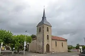 The church of Saint-Germé | |
Location of Saint-Germé | |
 Saint-Germé  Saint-Germé | |
| Coordinates: 43°40′52″N 0°08′43″W | |
| Country | France |
| Region | Occitania |
| Department | Gers |
| Arrondissement | Mirande |
| Canton | Adour-Gersoise |
| Government | |
| • Mayor (2020–2026) | Philippe Poitreau[1] |
| Area 1 | 9.55 km2 (3.69 sq mi) |
| Population | 498 |
| • Density | 52/km2 (140/sq mi) |
| Time zone | UTC+01:00 (CET) |
| • Summer (DST) | UTC+02:00 (CEST) |
| INSEE/Postal code | 32378 /32400 |
| Elevation | 89–110 m (292–361 ft) (avg. 102 m or 335 ft) |
| 1 French Land Register data, which excludes lakes, ponds, glaciers > 1 km2 (0.386 sq mi or 247 acres) and river estuaries. | |
Geography
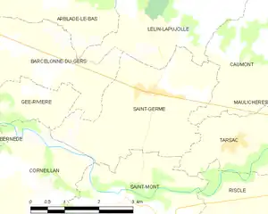
Saint-Germé and its surrounding communes
Population
| Year | Pop. | ±% |
|---|---|---|
| 1962 | 511 | — |
| 1968 | 508 | −0.6% |
| 1975 | 523 | +3.0% |
| 1982 | 488 | −6.7% |
| 1990 | 471 | −3.5% |
| 1999 | 443 | −5.9% |
| 2008 | 501 | +13.1% |
See also
References
- "Répertoire national des élus: les maires". data.gouv.fr, Plateforme ouverte des données publiques françaises (in French). 9 August 2021.
- "Populations légales 2020". The National Institute of Statistics and Economic Studies. 29 December 2022.
Wikimedia Commons has media related to Saint-Germé.
This article is issued from Wikipedia. The text is licensed under Creative Commons - Attribution - Sharealike. Additional terms may apply for the media files.