Saint-Cirgues-sur-Couze
Saint-Cirgues-sur-Couze (French pronunciation: [sɛ̃ siʁɡ syʁ kuz]; Occitan: Sent Cirgue de Cosa) is a commune in the Puy-de-Dôme department in Auvergne in central France.[3]
Saint-Cirgues-sur-Couze | |
|---|---|
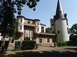 The entrance to the chateau in Saint-Cirgues-sur-Couze | |
Location of Saint-Cirgues-sur-Couze | |
 Saint-Cirgues-sur-Couze  Saint-Cirgues-sur-Couze | |
| Coordinates: 45°33′00″N 3°08′35″E | |
| Country | France |
| Region | Auvergne-Rhône-Alpes |
| Department | Puy-de-Dôme |
| Arrondissement | Issoire |
| Canton | Le Sancy |
| Intercommunality | Agglo Pays d'Issoire |
| Government | |
| • Mayor (2020–2026) | Philippe Garnavault[1] |
| Area 1 | 12.34 km2 (4.76 sq mi) |
| Population | 351 |
| • Density | 28/km2 (74/sq mi) |
| Time zone | UTC+01:00 (CET) |
| • Summer (DST) | UTC+02:00 (CEST) |
| INSEE/Postal code | 63330 /63320 |
| Elevation | 449–622 m (1,473–2,041 ft) (avg. 463 m or 1,519 ft) |
| 1 French Land Register data, which excludes lakes, ponds, glaciers > 1 km2 (0.386 sq mi or 247 acres) and river estuaries. | |
References
- "Répertoire national des élus: les maires" (in French). data.gouv.fr, Plateforme ouverte des données publiques françaises. 13 September 2022.
- "Populations légales 2020". The National Institute of Statistics and Economic Studies. 29 December 2022.
- "Commune de Saint-Cirgues-sur-Couze (63330)". www.insee.fr. Retrieved 17 July 2021.
Wikimedia Commons has media related to Saint-Cirgues-sur-Couze.
This article is issued from Wikipedia. The text is licensed under Creative Commons - Attribution - Sharealike. Additional terms may apply for the media files.