Paslières
Paslières ([paljɛʁ][3]) is a commune in the Puy-de-Dôme department in Auvergne in central France.[4]
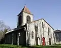 Saint-Bonnet church, hamlet of Croix Saint-Bonnet
Paslières | |
|---|---|
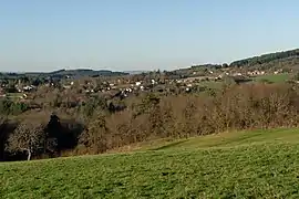 The hamlets of Joub and Bazelet in Paslières | |
.svg.png.webp) Coat of arms | |
Location of Paslières | |
 Paslières  Paslières | |
| Coordinates: 45°55′44″N 3°29′53″E | |
| Country | France |
| Region | Auvergne-Rhône-Alpes |
| Department | Puy-de-Dôme |
| Arrondissement | Thiers |
| Canton | Maringues |
| Government | |
| • Mayor (2020–2026) | Patrick Sauzedde[1] |
| Area 1 | 27.77 km2 (10.72 sq mi) |
| Population | 1,478 |
| • Density | 53/km2 (140/sq mi) |
| Time zone | UTC+01:00 (CET) |
| • Summer (DST) | UTC+02:00 (CEST) |
| INSEE/Postal code | 63271 /63290 |
| Elevation | 275–800 m (902–2,625 ft) (avg. 420 m or 1,380 ft) |
| 1 French Land Register data, which excludes lakes, ponds, glaciers > 1 km2 (0.386 sq mi or 247 acres) and river estuaries. | |
References
- "Répertoire national des élus: les maires" (in French). data.gouv.fr, Plateforme ouverte des données publiques françaises. 4 May 2022.
- "Populations légales 2020". The National Institute of Statistics and Economic Studies. 29 December 2022.
- Team, Forvo. "Paslières pronunciation: How to pronounce Paslières in French". Forvo.com. Retrieved 2018-10-18.
- INSEE commune file
Wikimedia Commons has media related to Paslières.
This article is issued from Wikipedia. The text is licensed under Creative Commons - Attribution - Sharealike. Additional terms may apply for the media files.