Saint-Bresson, Gard
Saint-Bresson (French pronunciation: [sɛ̃ bʁɛsɔ̃]; Occitan: Sent Breçon) is a commune in the Gard department in the Occitanie region in southern France.
Saint-Bresson | |
|---|---|
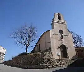 The church of Saint-Bresson | |
.svg.png.webp) Coat of arms | |
Location of Saint-Bresson | |
 Saint-Bresson  Saint-Bresson | |
| Coordinates: 43°57′15″N 3°38′48″E | |
| Country | France |
| Region | Occitania |
| Department | Gard |
| Arrondissement | Le Vigan |
| Canton | Le Vigan |
| Intercommunality | Pays Viganais |
| Government | |
| • Mayor (2020–2026) | Patrick Darlot[1] |
| Area 1 | 8.4 km2 (3.2 sq mi) |
| Population | 66 |
| • Density | 7.9/km2 (20/sq mi) |
| Time zone | UTC+01:00 (CET) |
| • Summer (DST) | UTC+02:00 (CEST) |
| INSEE/Postal code | 30238 /30440 |
| Elevation | 229–708 m (751–2,323 ft) (avg. 460 m or 1,510 ft) |
| 1 French Land Register data, which excludes lakes, ponds, glaciers > 1 km2 (0.386 sq mi or 247 acres) and river estuaries. | |
Population
| Year | Pop. | ±% |
|---|---|---|
| 1962 | 64 | — |
| 1968 | 73 | +14.1% |
| 1975 | 69 | −5.5% |
| 1982 | 53 | −23.2% |
| 1990 | 48 | −9.4% |
| 1999 | 52 | +8.3% |
| 2008 | 65 | +25.0% |
See also
References
- "Répertoire national des élus: les maires". data.gouv.fr, Plateforme ouverte des données publiques françaises (in French). 2 December 2020.
- "Populations légales 2020". The National Institute of Statistics and Economic Studies. 29 December 2022.
Wikimedia Commons has media related to Saint-Bresson (Gard).
This article is issued from Wikipedia. The text is licensed under Creative Commons - Attribution - Sharealike. Additional terms may apply for the media files.