Palo Verde, Arizona
Palo Verde is a small populated place in Maricopa County, Arizona, United States. It is located about 40 miles (64 km) west of Phoenix, and 6 miles (9.7 km) southwest of downtown Buckeye on Historic U.S. Route 80.
Palo Verde, Arizona | |
|---|---|
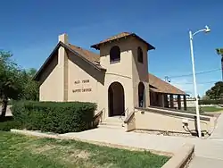 The Palo Verde Baptist Church was built in 1890 and is located on 29600 West Old Hwy. 80. | |
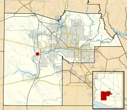 Location in Maricopa County and the state of Arizona | |
| Coordinates: 33°20′53″N 112°40′39″W | |
| Country | United States |
| State | Arizona |
| County | Maricopa |
| Elevation | 845 ft (258 m) |
| Time zone | UTC-7 (Mountain (MST)) |
| ZIP code | 85343[1] |
| Area code | 623 |
Brief history
The Palo Verde area was settled in 1886, by John G. Roberts and family. Mr. Roberts helped in the construction of the Arizona and Buckeye canals, served a term as cattle inspector, and was deputy sheriff at Buckeye under three Maricopa County sheriffs.[2][3] One of the first structures built, which still stands, was the Palo Verde Baptist Church, organized in 1890.[4]
Despite sharing a name, the Palo Verde Nuclear Generating Station is located in nearby Wintersburg.
Palo Verde exists as a county island within the planning boundary of Buckeye. This precludes any possibility of incorporation for the community, but annexation into Buckeye is a possibility.
In 1995, a train derailment occurred near the town of Palo Verde.


References
- "Palo Verde ZIP Code". zipdatamaps.com. 2022. Retrieved November 11, 2022.
- "Wickenburg Sun Obituaries"; July 30, 1954; page 5]
- Arizona Obituary Archive
- Early History of Buckeye
Municipalities and communities of Maricopa County, Arizona, United States | ||
|---|---|---|
| Cities |  | |
| Towns | ||
| CDPs | ||
| Populated places |
| |
| Indian reservations | ||
| Ghost towns/ former populated places | ||
| Footnotes | ‡This populated place also has portions in an adjacent county or counties | |