Maricopa Colony, Arizona
Maricopa Colony is a census-designated place (CDP) in Maricopa County, Arizona, United States, located in the federally recognized Gila River Indian Community. The population was 854 at the 2020 census,[2] up from 709 at the 2010 census. It is located on the southern side of the Phoenix metropolitan area, around Baseline Road and 83rd Avenue.
Maricopa Colony, Arizona | |
|---|---|
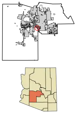 Location in Maricopa County, Arizona | |
 Maricopa Colony  Maricopa Colony | |
| Coordinates: 33°22′35″N 112°14′12″W | |
| Country | United States |
| State | Arizona |
| County | Maricopa |
| Area | |
| • Total | 5.49 sq mi (14.21 km2) |
| • Land | 5.49 sq mi (14.21 km2) |
| • Water | 0.00 sq mi (0.00 km2) |
| Population | |
| • Total | 854 |
| • Density | 155.70/sq mi (60.12/km2) |
| Time zone | UTC-7 (MST (no DST)) |
| ZIP code | 85339[3] |
| Area code | 520 |
| FIPS code | 04-44450 |
Demographics
| Census | Pop. | Note | %± |
|---|---|---|---|
| 2010 | 709 | — | |
| 2020 | 854 | 20.5% | |
| U.S. Decennial Census[4] | |||
As of the census[5] of 2010, there were 709 people living in the CDP. The racial makeup of the CDP was 1% White, 92% Native American, 4% from other races, and 3% from two or more races. 14% of the population were Hispanic or Latino of any race.
Notes
- "2021 U.S. Gazetteer Files: Arizona". United States Census Bureau. Retrieved May 17, 2022.
- "Maricopa Colony CDP, Arizona: 2020 DEC Redistricting Data (PL 94-171)". U.S. Census Bureau. Retrieved May 17, 2022.
- "Maricopa Colony AZ ZIP Code". zipdatamaps.com. 2023. Retrieved May 3, 2023.
- "Census of Population and Housing". Census.gov. Retrieved June 4, 2016.
- "American FactFinder". Archived from the original on July 21, 2011. Retrieved July 9, 2011.
- "West End Shuttle - Gila River Transit".
Municipalities and communities of Maricopa County, Arizona, United States | ||
|---|---|---|
| Cities |  | |
| Towns | ||
| CDPs | ||
| Populated places |
| |
| Indian reservations | ||
| Ghost towns/ former populated places | ||
| Footnotes | ‡This populated place also has portions in an adjacent county or counties | |
This article is issued from Wikipedia. The text is licensed under Creative Commons - Attribution - Sharealike. Additional terms may apply for the media files.