Périers, Manche
Périers [peʁje] is a commune in the Manche department in Normandy in north-western France.
Périers | |
|---|---|
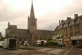 The church of Saint-Pierre-et-Saint-Paul on market day | |
.svg.png.webp) Coat of arms | |
Location of Périers | |
 Périers  Périers | |
| Coordinates: 49°11′14″N 1°24′22″W | |
| Country | France |
| Region | Normandy |
| Department | Manche |
| Arrondissement | Coutances |
| Canton | Agon-Coutainville |
| Government | |
| • Mayor (2020–2026) | Gabriel Daube[1] |
| Area 1 | 14.62 km2 (5.64 sq mi) |
| Population | 2,244 |
| • Density | 150/km2 (400/sq mi) |
| Time zone | UTC+01:00 (CET) |
| • Summer (DST) | UTC+02:00 (CEST) |
| INSEE/Postal code | 50394 /50190 |
| Elevation | 6–36 m (20–118 ft) (avg. 29 m or 95 ft) |
| 1 French Land Register data, which excludes lakes, ponds, glaciers > 1 km2 (0.386 sq mi or 247 acres) and river estuaries. | |
History
Périers was liberated by the 2nd Battalion, 359th Infantry Regiment, 90th Division, of the United States Army, on 27 July 1944.[3]
Heraldry
Arms of Périers |
The arms of Périers are blazoned : Argent, a pear tree eradicated vert and in base a barrulet gules, overall on a bend azure between 2 lions sable, 3 mullets pierced (spur-rowels) Or.
|
See also
References
- "Répertoire national des élus: les maires" (in French). data.gouv.fr, Plateforme ouverte des données publiques françaises. 13 September 2022.
- "Populations légales 2020". The National Institute of Statistics and Economic Studies. 29 December 2022.
- 90th Infantry Division "Tough' Ombres" Archived 2011-07-24 at the Wayback Machine. - Memorial of Coudehard - Montormel. - Retrieved: 2010-12-05
Wikimedia Commons has media related to Périers.
This article is issued from Wikipedia. The text is licensed under Creative Commons - Attribution - Sharealike. Additional terms may apply for the media files.